Interim and future corridors
Future transport corridors are identified and protected from development through Environmental Planning Instruments.
Environmental Planning Instruments include the Transport and Infrastructure SEPP, Preceincts - Central River City SEPP, Precincts - Western Parkland City SEPP and more.
Depending on the specific circumstances, these corridors are identified as either planning overlays (usually marked as cross hatched in EPIs or sometime as a designated zone (such as SP2). Land so affected can be identified in maps on the NSW Government Legislation website associated with each of the EPIs, or via the NSW Government eSpatial viewer.
Note that the future infrastructure corridors are also protected from activities of other public authorities (carried out under Part 5.1 of the EP&A Act) in accordance with Part 5 Division 5.3 of the EP&A Act.
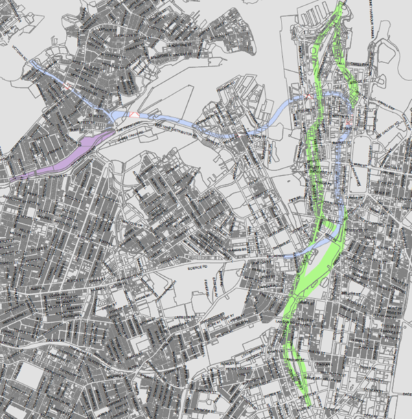
Interim rail corridors
A high level map showing the interim rail corridors is shown below.
Image
Image controls:
Note the Interim Rail Corridors are protected through the operation of Clause 2.100 of State Environmental Planning Policy (Transport and Infrastructure) 2021. If development is within the notification area (ie on or within 25m of the corridor) and involves major development, or excavation, or increases the height of existing development by more than 10m, then concurrence of Transport needs to be sought from the consent authority before consent can be granted to such development.
If development is affected by Interim Rail Corridor, then there are standard requirements for documentation that needs to be submitted with the review of environmental factors, statement of environmental effects or environmental impact assessment. Transport can provide further information – please contact development@transport.nsw.gov.au
Outer Sydney Orbital
The Outer Sydney Orbital is a proposed corridor for a motorway and freight rail line in Western Sydney that would be signposted M9 or M10. The recommended corridor of land for the Outer Sydney Orbital Stage 1 will provide for a major transport link between the North West and South West Growth Areas, connecting with the planned Western Sydney Airport and future employment lands.
If development is affected by Outer Sydney Orbital Corridor, then there are standard requirements for documentation that needs to be submitted with the review of environmental factors, statement of environmental effects or environmental impact assessment. Transport can provide further information – please contact development@transport.nsw.gov.au
North South Rail Link
The North South Rail Line corridor will provide for a passenger rail connection between the Main West Line near St Marys and the Main South Line near Macarthur. Tunnel sections have been identified between St Marys and south of the M4 Motorway, and between Oran Park, and the Main South Line near Macarthur, to avoid existing communities and to preserve bushland.
If development is affected by North South Rail Link, then there are standard requirements for documentation that needs to be submitted with the review of environmental factors, statement of environmental effects or environmental impact assessment. Transport can provide further information – please contact development@transport.nsw.gov.au
East West Rail Link
The East West Rail Link is a proposed future mass transit rail line connecting Greater Parramatta and the Western Sydney Aerotropolis and International Airport. The corridor protection for the East West Rail Link was a recommendation of the Western Sydney Rail Needs Scoping Study.
This future transport link will form a critical part of the Western Sydney Aerotropolis Plan by ensuring communities in the Central River City are connected to the Western Parkland City and the Western Sydney Airport (Nancy-Bird Walton).
If development is affected by East West Rail Link, then there are standard requirements for documentation that needs to be submitted with the review of environmental factors, statement of environmental effects or environmental impact assessment. Transport can provide further information – please contact development@transport.nsw.gov.au
Aerotropolis Transport Network
The Australian and NSW governments are partnering to deliver a 10-year, $4.1 billion road investment program for Western Sydney.
The Western Sydney Infrastructure Plan is designed to capitalise on the economic benefits of the Western Sydney Airport as part of an integrated transport solution for the Western Sydney region.
Included in the program are the new Werrington Arterial Road, and upgrades to Bringelly Road, The Northern Road and the intersection of Ross Street and the Great Western Highway at Glenbrook. The new M12 Motorway running from the M7 in the east to The Northern Road in the west will provide access to the airport.
If development is within the Western Sydney Aerotropolis, then there are standard requirements for documentation that needs to be submitted with the review of environmental factors, statement of environmental effects or environmental impact assessment. Transport can provide further information – please contact development@transport.nsw.gov.au
Western Sydney Freight Line
The Western Sydney Freight Line will be a proposed dedicated freight rail line connection between the Western Parkland City and Port Botany. With the aim of reducing congestion on local roads, this new freight line will allow the transport of goods by rail across Greater Sydney, linking growing industrial areas and distribution centres including the announced Intermodal terminal site in the Mamre Road Precinct.
The new freight rail line will also free up the Main West Rail Line to allow more passenger services over time.
If development is affected by the Western Sydney Freight Line, then there are standard requirements for documentation that needs to be submitted with the review of environmental factors, statement of environmental effects or environmental impact assessment. Transport can provide further information – please contact development@transport.nsw.gov.au
Lower Hunter Freight Corridor
The Lower Hunter Freight Corridor will provide for future alleviation of pressure on the rail network by allowing additional freight capacity which will help reduce freight services through Newcastle.
This will improve amenity for local communities, and enable both freight and passenger rail capacity to grow. A dedicated freight rail line will also encourage road freight onto rail to reduce road congestion, and reduce delays for road users at level crossings near St James Road, Adamstown and Clyde Street, Islington.
If development is affected by the Lower Hunter Freight Corridor, then there are standard requirements for documentation that needs to be submitted with the review of environmental factors, statement of environmental effects or environmental impact assessment. Transport can provide further information – please contact development@transport.nsw.gov.au