Holbrook Bypass
Holbrook Bypass
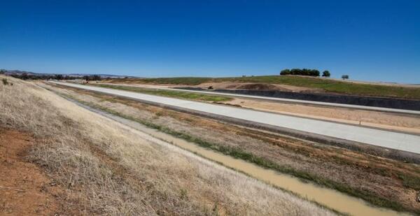
The Holbrook bypass is approximately 9.5km long, and runs from 4km north of Holbrook, where it deviates west from the existing dual carriageways to cross Wagga Wagga Road.
Image
Image controls:
Image
Image controls:
Bypassed towns signage trial
The bypassed towns signage trial aims to encourage travellers to stop and visit bypassed towns in regional and rural NSW. Holbrook, Macksville and Berry are part of the trial.
About the project
The $247 million Holbrook bypass opened to traffic on Wednesday 7 August 2013, and was funded by the Australian and NSW governments.
The 9km bypass was built to the west of Holbrook to improve safety and transport efficiency. It runs from 4km north of Holbrook where it deviates west from the existing dual carriageways to cross Wagga Wagga Road.
The bypass crosses the former Town Common area, passing to the west of the cemetery, sewage treatment works and industrial area and then across Culcairn Road.
From Culcairn Road the bypass crosses Ten Mile Creek and rejoins the existing dual carriageway two kilometres south of Holbrook.
The Holbrook bypass was designed by Transport for NSW (TfNSW) and constructed by Abigroup.
Features
- 4 lane divided carriageway with a 110km/h speed limit.
- A full-diamond northern interchange on Wagga Wagga Road with northbound and southbound on and off load ramps.
- A full-diamond southern interchange near the existing Hume Highway with southbound and northbound on and off load ramps.
- Twin bridges over Culcairn Road.
- Twin bridges over Ten Mile Creek.
- Landscape and urban design treatments to minimise visual impact and provide 'gateway' treatments to Holbrook.
- Environmental controls to minimise impacts on nearby waterways and natural areas.
Benefits
- Remove many heavy vehicles from residential and shopping areas of Holbrook.
- Improve pedestrian safety along the current Hume Highway route through Holbrook.
- Reduce traffic noise for residents and businesses, particularly at night.
- Travel time and fuel savings for vehicles moving between Sydney and Melbourne.
Construction history
- June to August 2013:
- Completion of all bridges.
- Finalisation of property works.
- Concrete and asphalt paving.
- Installation of line marking, signage, guide posts etc.
- Final traffic switch and open to traffic.
- April to May 2013:
- Completion of earthworks.
- Traffic north of Holbrook was moved to a new section of highway, about 1.5 kilometres to the north of the connection with the original highway.
- Noise mitigation works.
- Concrete and asphalt paving.
- Installation of signage, guide posts etc.
- Topsoiling and revegetation works.
- February to March 2013:
- Reconstruct the northbound carriageway south of Holbrook.
- Concrete paving works.
- Construction north of Holbrook, linking the new southbound sections of carriageway.
- Installation and painting of the noise walls.
- Installation of fauna corridor poles.
- Landscaping and grass sowing.
- Drainage works at both ends of the project.
- Bulk earthworks for the Albury Street southbound on-ramp in preparation for paving work.
- Reconstruction of Culcairn Road where it crosses the construction corridor.
- September 2012 to January 2013:
- Bulk earthworks were completed.
- Final shaping and grass sowing of the cut started.
- The majority of drainage works were completed.
- Asphalt paving of the southern end of the southbound carriageway was completed.
- Work on the Wagga Road interchange was completed.
- The bridge and Wagga Road re-opened to traffic on 16 November 2012.
- Culcairn Road bridge works were completed.
- Ten Mile Creek bridge works were completed.
- Albury Street bridge works were completed.
- Traffic was moved on to the existing northbound lane with two way traffic, about four kilometres south of Holbrook, on 1 November 2012.
- Traffic was moved on to the new southbound carriageway (about two kilometres in length) to allow for reconstruction of the new northbound carriageway, on 7 December 2012.
- Installation of noise wall started.
- Work continued on the placement of selected material in pavement.
- Concrete paving along the main alignment of the project continued.
- May to August 2012:
- Bulk earthworks.
- Drainage works.
- Wagga Road interchange works.
- Abutment piling on the Culcairn Road bridge. Bridge girders placed and concrete deck completed.
- Installation of the abutment piles and construction of the abutment headstocks on Ten Mile Creek bridge.
- Traffic was moved onto the new section of road north of Holbrook to enable tie-in works to the new bypass to be constructed.
- Test piling was carried out on the Albury Street southern interchange bridge. Abutment piles were installed.
- Concrete paving continued from the northern end of the project.
- January to April 2012:
- Completion of the Holbrook Tip access road.
- Establishment of the concrete batch plant at Rocklea Falls Quarry in preparation for road paving.
- Over 1 million m3 of earth moved along the alignment of the bypass.
- Over 800 culvert units placed.
- 263 nesting boxes placed in vegetation to accommodate potentially disturbed fauna such as squirrel gliders, parrots, owls and bats.
- Completion of Wagga Road abutment piling.
- Completion of bridge columns on 10 Mile Creek Bridge.
- Completion of earthworks from the cut at the northern end of the project and placement of select quarry pavement materials along the northern section in preparation for concrete paving.
Environmental assessment
An environmental assessment of the benefits and potential impacts of the preferred option was on display for community comment from Wednesday 11 November 2009 to Monday 14 December 2009.
Potential impacts and environmental management
As part of the planning approval process an environmental assessment was prepared and displayed under part 3A of the Environmental Planning and Assessment Act 1979. The environmental assessment examines the potential impacts of the project during construction and operation and the measures proposed to reduce and manage these impacts.
The assessment focuses on the key issues and for the Holbrook bypass, these include impacts on:
- Flora and fauna
- Aboriginal heritage
- noise and vibration
- social and economic
- traffic and transport.
Examples of environmental management measures to minimise impacts include:
- Limiting the extent of clearing, revegetating land and implementing erosion and sedimentation controls.
- Maintaining vegetation connectivity and installation of crossing measures for the safe movement of fauna across the highway.
- Landscape and urban design treatments to recognise Holbrook as a 'rest town'.
- Construction of water quality basins and other measures to treat run-off during construction and operation.
- Treatment to reduce noise impacts at selected locations which may include noise mounds, noise walls, low noise road surface or the individual treatment of homes.
- Modification of local roads and property accesses to ensure efficient access to and across the proposed upgrade.
The Holbrook Bypass Environmental Assessment, working papers and submissions report are available.
Please contact us for details.
Photo gallery
Image


Image controls:
Image


Image controls: