Alfords Point Road, Illawong/Alfords Point
Project overview
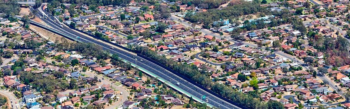
The NSW Government has completed the $40 million upgrade to widen Alfords Point Road between the Georges River and Brushwood Drive.
Latest news
Oct 2017 - Project completed
Roads and Maritime Services has opened the new six lane Alfords Point Road. The 2.1k project will be completed two months ahead of schedule in October 2017.
Project information
Noise wall project
Roads and Maritime has engaged GHD to investigate the feasibility of a noise barrier on top of the rock face between Nallada Road and Marlock Place. The investigation included noise modelling, environmental and geotechnical investigations, alignment surveying and constructability feasibility.
The feasibility report identified a potential alignment at the back of the rock face near the property boundaries with a wall height of 4.5 metres. We are looking at two designs for the wall, a full 4.5 metre hebel wall and a 2.7 metre hebel wall with 1.8 metre clear Perspex top. We have design a visualisation and animation to show residents what the noise barriers may look like and a visualisation of a ‘do nothing’ approach.
Project update
Roads and Maritime has completed major construction work including:
- relocation of Telstra assets
- construction of a new Heavy Vehicle Inspection Station on the eastern side of Alfords Point Road, under the Old Illawarra Road overbridge
- major earthwork on the eastern side of Alfords Point Road
- concrete shared path on the eastern side of Alfords Point Road
- eastern and western rock face stabilisation work
- construction of the eastern noise wall
- installation of the concrete barrier separating the north and souhtbound carriageway
- completion of the new southbound lanes.
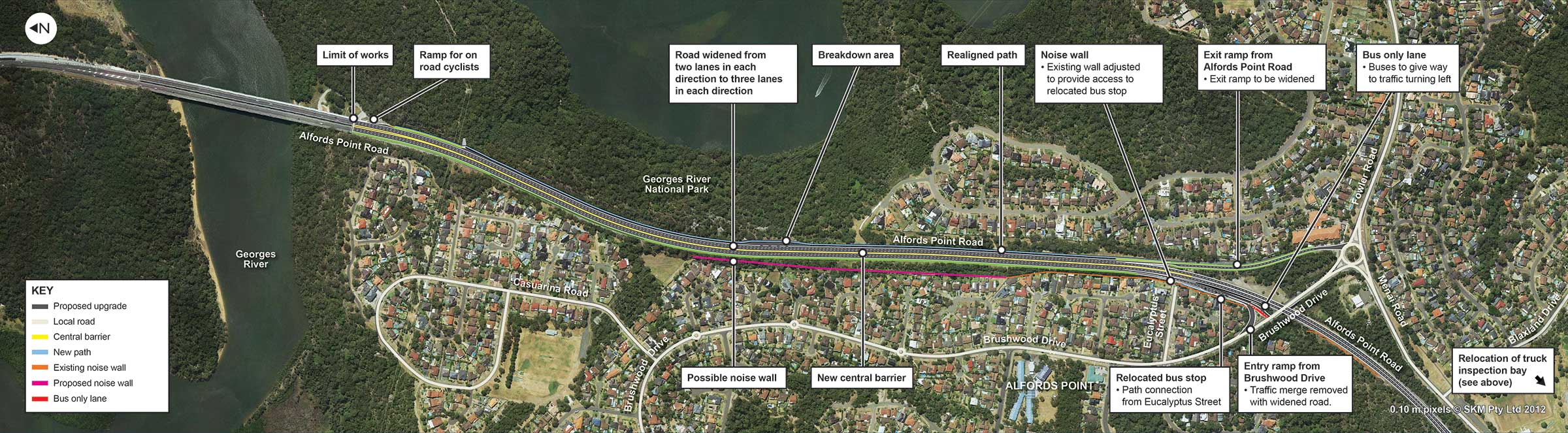
Key features
- Widening Alfords Point Road between Georges River and Brushwood Drive from two lanes to three lanes in each direction
- Improving traffic flow to and from Brushwood Drive on and off-ramps by using the new lanes
- Providing a central barrier to improve safety by dividing the northbound and southbound carriageways
- Relocating the northbound bus bay on Alfords Point Road on-ramp near Eucalyptus Street, to a location around 100 metres to the south
- Providing a new road surface and improved drainage system
- Providing a breakdown bay along the southbound carriageway located around midway between the Georges River and Brushwood Drive
- Relocating the Heavy Vehicle Inspection Station on the southbound carriageway to beneath the Old Illawarra Road bridge, around 900 metres south of Brushwood Drive
- Realigning the pedestrian path on the eastern side of Alfords Point Road
- Adjusting existing noise walls and providing a new noise wall along the route
- Providing cycleway access from Alfords Point Road.
Background
Alfords Point Road is an important road in southern Sydney, providing access across the Georges River for motorists, commuters, cyclists and freight vehicles. Roads and Maritime Services has been working to reduce congestion, improve travel times and improve road safety on the route by completing the duplication of Alfords Point Bridge in 2008 and the opening to traffic of the Alfords Point Bridge Northern Approach in late 2011.
Preliminary investigations for the Alfords Point Road Southern Approach project were carried out in 2012, including ground surveys, geotechnical investigations, flora and fauna studies, noise monitoring, examination of heritage and assessment of aboriginal cultural significance issues.
Roads and Maritime prepared a Review of Environmental Factors to assess the environmental impacts of the proposal, which was placed on public display from 28 February to 5 April 2013. Roads and Maritime finalised the detailed design of this 2.1 kilometre upgrade and invited tenders to construct the upgrade in September 2015.
Further information on the environmental assessment and community feedback is available on the project documents page.
Project objectives
- Widen Alfords Point Road between Georges River and Brushwood Drive from two lanes to three lanes in each direction
- Improve traffic flow to and from Brushwood Drive on and off ramps by using the new lanes.
Community information
Community engagement
Roads and Maritime Services prepared a Review of Environmental Factors (REF) to assess the environmental impacts of the proposal. The REF was placed on public display from 28 February 2013 until 5 April 2013 at three locations across Sutherland, Menai and Padstow.
A total of 25 submissions were received in response to the public display, comprising three from government agencies (Sutherland Shire Council, Office of Environment and Heritage, Heritage Council of NSW) and 22 submissions from the community.
A submissions report summarised the issues raised and provided responses to each issue. The main issues raised by the community included:
- Impacts to traffic flows, safety and access to an existing bus stop
- Noise and vibration impacts and the location and use of noise barriers
- Impacts to heritage, biodiversity and soil and water quality
- Design of certain aspects of the proposal, such as barriers, ramp design and bus stop location
- Potential impacts to amenity and safety.
There have been some changes to the project as a result of community feedback, including revised safeguards and management measures.
Frequently asked questions (FAQs)
Project need and benefits
- Why are you upgrading Alfords Point Road?
Roads and Maritime Services is upgrading 2.1 kilometres of Alfords Point Road between Brushwood Drive and the Georges River at Alfords Point. The upgrade forms part of a broader plan to improve traffic flow along Alfords Point Road and through the southern region of Sydney.
- What are the key features of the road upgrade?
- Upgrade about 2.1 kilometres of Alfords Point Road from a four lane undivided carriageway to a six lane divided carriageway. Alfords Point Road will be widened on the eastern side to accommodate three lanes in each direction
- A central barrier to improve safety by dividing the northbound and southbound carriageways
- Relocate the northbound bus bay on Alfords Point Road on-ramp near Eucalyptus Street, to a location around 100 metres to the south
- New road surface and improved drainage system
- A breakdown bay along the southbound carriageway located approximately mid-way between the Georges River and Brushwood Drive
- Truck inspection area on the southbound carriageway relocated to beneath Old Illawarra Road bridge, around 900 metres south of Brushwood Drive
- Realign the pedestrian path on the eastern side of Alfords Point Road
- Adjust existing noise walls, possible provision of noise barriers and/or architectural treatments to address noise issues.
- What are the benefits of the road upgrade?
- Reducing congestion
- Improved travel times
- Improved road safety
- What is the background of this project?
Alfords Point Road is an important road in southern Sydney, providing access across the Georges River for motorists, commuters, cyclists and freight vehicles. Roads and Maritime has been working to reduce congestion, improve travel times and improve road safety on the route by completing the duplication of Alfords Point Bridge in 2008 and the opening to traffic of the Alfords Point Bridge Northern Approach in late 2011.
Preliminary investigations for the Alfords Point Road Southern Approach project were carried out in 2012, which included ground surveys, geotechnical investigations, flora and fauna studies, noise monitoring, examination of heritage and assessment of aboriginal cultural significance issues.
Roads and Maritime prepared a Review of Environmental Factors (REF) to assess the environmental impacts of the proposal, which was placed on public display from 28 February to 5 April 2013. A total of 25 submissions were received in response to the public display of the REF. There have been some changes to the project as a result of community feedback, including revised safeguards and management measures.
Roads and Maritime finalised the detailed design of this 2.1 kilometre upgrade and invited tenders to construct the upgrade in September 2015.
Funding
- What is the cost of the project?
The estimated cost of the project is $40 million.
Construction
- When will construction occur?
Major construction work started in April 2016 and will take around 18 months to complete, weather permitting.
- What are the upcoming project milestones?
Completion of the southbound lane construciton (June 2017)
- Why has it taken so long to get project construction going?
Since the initial concept design there has been extensive consultation carried out with residents who live along the project area and the wider community. This consultation has taken time, particularly regarding noise management for nearby residents. Roads and Maritime has also developed traffic management plans to minimise disruption to traffic on this arterial road during construction.
- What early work have you been doing?
Early work started in March 2016 and included:
- Establishing the site compound (near the Brushwood Drive off-ramp)
- Carrying out preconstruction surveys of nearby homes
- Installing a pedestrian/cycling detour for the duration of the southbound widening construction from Maxwell Close to Brushwood Drive off-ramp
- Installing protective concrete barriers along the roadway, which will be in place for the duration of the project
- Clearing vegetation on the eastern side of Alfords Point Road, between Maxwell Close and the intersection of Brushwood Drive and Fowler Road.
- What major construction work is being carried out?
Major construction work started in May 2016 and includes:
- Construction of a new heavy vehicle inspection bay on the eastern side of Alfords Point Road, under the Old Illawarra Road overbridge
- Major earthwork on the eastern side of Alfords Point Road
- Installation of a pedestrian/cycling detour for the duration of the southbound widening construction, from Maxwell Close to Brushwood Drive off-ramp
- Construction of the Brushwood Drive off-ramp
- Eastern rock face stabilisation work
- Construction of the eastern noise wall
- Relocation of Telstra assets.
- What are your construction hours?
Construction will generally be carried out during standard construction hours including 7am to 6pm Monday to Friday and occasionally on Saturdays between 8am and 1pm, weather permitting.
Some work will need to be carried out at night to maintain safety measures, lessen impact on the road network and maintain the service continuity of utilities when they are being relocated. All work outside of standard construction hours will be carried out in accordance with the relevant approvals and residents and businesses will be notified in advance.
- How will you manage construction impact?
There will be some disruption while we complete this work including changed traffic conditions, noise, vibration, dust, lighting during night work and access to property. Construction activities will be carried out in accordance with the project’s Construction Environmental Management Plan.
We will make every effort to minimise impacts by:
- Notifying residents in advance of work
- Carrying out work during standard construction hours wherever possible
- Servicing and maintaining machinery and equipment to limit noise and emissions
- Temporary, electronic message signs will also be installed to inform motorists of upcoming work and changed traffic conditions.
- What will happen at Brushwood Drive on-ramp?
Currently, peak hour traffic merging from the Brushwood Drive on-ramp onto Alfords Point Road creates heavy congestion along Brushwood Drive. As part of the project, the Brushwood Drive and Alfords Point Road merge point will be removed and traffic conditions and signage will be changed to improve road safety and travel times. We will notify the community well before this change happens.
- What noise mitigation techniques are in use for residents?
During the detailed design stage, investigations were carried out on feasible and reasonable noise mitigation. Noise reduction measures of the project include the extension of an existing noise wall, construction of a new noise and architectural upgrades for properties identified with the potential to experience increased noise as a result of the project.
- Why is bus stop on Brushwood Drive on-ramp being relocated?
The existing bus stop on Brushwood Drive on-ramp is in a location with poor sight distances. Relocating the bus stop around 100 metres south will reduce congestion on the Brushwood Drive on-ramp, reduce the likelihood of vehicle crashes and improve road safety for motorists and pedestrians.
Project photo/map
Contact us
For further information about this project, please contact:
Email: Alfordspoint@rms.nsw.gov.au.