M6 Stage 1
Project overview
In December 2019, the M6 Stage 1 (previously referred to as the F6 Extension Stage 1) received planning approval from the Department of Planning, Industry and Environment.
Transport for NSW has awarded the design and construction contract for the M6 Stage 1 to CIMIC Group's CPB Contractors and UGL in a joint venture with Ghella. The project is a key element of the NSW Government's transport vision for NSW, connecting Sydney’s south to the wider motorway network.
Interactive portal
To learn more about this project, view our interactive portal for more information.
Project information
Background
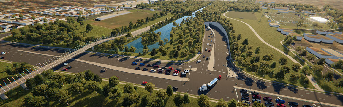
The M6 Stage 1 will deliver the missing link from Sydney’s south to the wider Sydney motorway network making journeys easier, faster and safer. It will remove more than 2,000 trucks a day from surface roads, and help return local streets to local communities.
Future Transport Strategy 2056 is the NSW Government's 40 year vision for transport outcomes in NSW. The M6 Stage 1 is a key part of this strategy, supporting safe, efficient and reliable journeys for people and freight.
The M6 Stage 1 includes:
- Twin four kilometre tunnels linking the M8 Motorway at Arncliffe to President Avenue at Kogarah
- Ramps between the main motorway tunnel and the surface intersection at President Avenue
- Tunnel stubs for a future connection south to extend the M6
- A new intersection at President Avenue including the widening and raising of President Avenue at this location
- Provision of new shared cyclist and pedestrian pathways connecting Bestic Street, Brighton Le Sands
- Motorway support infrastructure including tunnel ventilation systems and the motorway control centre
- New service utilities including a permanent power supply line
- Minor adjustments to local roads in the project area.
The project budget is $3.1 billion. As a result of the subsidence incidents in early 2024, there will be a revised cost. Detailed analysis is being undertaken and more information will be available when the revised cost is known.
Main construction of the M6 Stage 1 started in January 2022. Currently 90 per cent of tunnelling is complete. Due to the subsidence incidents in early 2024, the M6 Stage 1 is targeted to open to traffic in late 2028.
Benefits
The M6 Stage 1 will:
- Enable motorists to bypass up to 23 sets of traffic lights on the Princes Highway between St Peters and Kogarah
- Be built mainly underground to minimise disruption to the community and property impacts
- Ease congestion, meaning less time in traffic and faster trips to the CBD and across Greater Sydney
- Reduce traffic on General Holmes Drive by 10,000 vehicles a day
- Improve travel times and provide more direct access from southern Sydney to the wider Sydney motorway network
- Improve pedestrian and cyclist safety through the new shared cyclist and pedestrian pathways
- Assist in the reduction of traffic congestion, particularly along Princes Highway through Arncliffe, Banksia and Rockdale, and The Grand Parade, Brighton Le Sands, and provide shorter travel times for road users
- Improve the amenity of the foreshore precinct at Brighton Le Sands at The Grand Parade through a reduction in traffic and returning local streets to local communities
- Reduce the number of trucks on surface roads by over 2,000 per day
- Allow motorists to bypass Sydney Airport traffic
- Contribute to a more accessible, more liveable and productive Greater Sydney.
Improving travel times
This project will deliver major travel time savings including:
| M6 Stage 1 | Travel Time savings |
|---|---|
| Kogarah to Anzac Bridge | 15 minutes |
| Kogarah to South Sydney | 13 minutes |
| Kogarah to the City | 8 minutes |
| Miranda to Macquarie Park | 15 minutes |
| Taren Point to Mascot | 12 minutes |
Air quality monitoring
Air quality in Sydney is good by national and international standards. According to data published by the World Health Organisation (WHO) who set global air quality guidelines, Sydney's air quality is better than their guidelines and the air quality of other global cities such as Washington, Helsinki, London and Paris.
In February 2018, the NSW Government announced stronger measures on emissions from motorway tunnels. These measures include the EPA regulating the ventilation facilities of all current and future operating motorway tunnels to ensure they meet air quality limits.
As part of these measures additional checks are required before the EIS for the project can be approved by the Minister for Planning. They involve:
- The Advisory Committee on Tunnel Air Quality (ACTAQ) coordinating a scientific review of the project’s air emissions from ventilation facilities
- The NSW Chief Health Officer releasing a statement on the potential health impacts of emissions from tunnel ventilation facilities.
The M6 Stage 1 is the first tunnel project that was required to implement these measures. The ACTAQ review and Chief Health Officer statement are available to view on the Department of Planning, Industry and Environment’s website. The air quality considerations are addressed in the Environmental Impact Statement, also available on the Department of Planning, Industry and Environment’s website.
Air quality modelling for the project showed that under expected traffic conditions for the project the predicted contribution of tunnel ventilation outlets to local air quality was negligible.
Existing measures monitoring the air quality inside motorway tunnels remain in place. View the tunnel ventilation technology online video.
Environmental planning
The M6 Stage 1 underwent a rigorous planning process with the Department of Planning, Industry and Environment granting planning approval in December 2019. The following documents supported the planning process:
- Secretary's Environmental Assessment Requirements
The Department of Planning, Industry and Environment (DPIE) issued the Secretary's Environmental Assessment Requirements (SEARS) for the project in December 2017. The SEARs established the issues that must be addressed and responded to in the Environmental Impact Statement (EIS). - State Significant Infrastructure Application
Transport for NSW submitted a State Significant Infrastructure Application with DPIE early in the planning process to identify issues that must be addressed in the Environmental Impact Statement. The State Significant Infrastructure Application (PDF, 608Kb)is available to view or download or can also be viewed on the DPIE Major Projects website. - Scoping Report
A Scoping Report was prepared by Transport for NSW to support the State Significant Infrastructure Application. The Scoping Report (PDF, 43.1Mb) is available to view or download or can also be viewed on the DPIE Major Projects website. - Environmental Impact Statement
The Environmental Impact Statement (EIS) examined all potential environmental and social impacts that may occur during the construction and operation of the project, and proposed mitigation measures to reduce these impacts. The EIS was publicly exhibited from 7 November to 14 December 2018, and is available to view or download on the DPIE Major Projects website. - Submissions and Preferred Infrastructure Reports
The Submissions Report and a Preferred Infrastructure Report (PIR) was prepared in response to submissions made by the community, councils and government agencies and are available to view or download on the DPIE Major Projects website. The PIR assesses alternative design options that were an outcome of the EIS exhibition. Two changes to the design have been made based on feedback received:- Traffic changes will include improved access arrangements on President Avenue
- The shared cyclist and pedestrian pathway will be extended further south to O'Connell Street, Kogarah.
The PIR was publicly exhibited from 17 April to 8 May 2019, and is available to view or download on the DPIE Major Project website.
- Planning approval
The Minister for Planning and Public Spaces has now approved the M6 Stage 1 project. As part of the approval process, there have been some further changes that will result in greater benefits and reduced impacts to the community. We're making these changes in response to the Conditions of Approval. Also known as the Signed Instrument of Approval, this is available to view or download on the DPIE Major Projects website.- One of the key changes means we will now build an off-road shared pedestrian and cyclist pathway that will replace the on road connection between Bruce Street and England Street in Brighton Le Sands. This change will improve safety and connectivity for the local community. For more information about the M6 Stage 1 Conditions of Approval, please visit the DPIE Major Projects website.
New recreational facilities
Our construction activities will have a temporary impact on open space and the recreational facilities at Rockdale Bicentennial Park. We understand how important this area is for you and we have continued to work with Bayside Council and the community to develop our plans to upgrade and build new facilities at Ador Park Precinct, McCarthy Reserve, Brighton Memorial Playing Fields, Rockdale before construction starts.
Your new recreational facilities will include the creation of new grass and synthetic playing fields, more car parking spaces as well as a new skate park and play areas.
We will stage the upgrades at Ador Park Precinct, McCarthy Park and Brighton Memorial Playing Fields to minimise impact to the existing facilities and soccer season.
On behalf of Bayside Council, we developed a concept design and Review of Environmental Factors (REF) (PDF, 7.95Mb) for the proposed recreational facilities at Rockdale and Brighton Le Sands. We invited feedback on the REF in December 2019.
Bayside Council considered your feedback and provided approval (PDF, 444Kb) in April 2020.
In July 2020, we prepared an Addendum Review of Environmental Factors (REF) (PDF, 2.24Mb) to assess a few changes to our project. Bayside Council have since considered and approved the Addendum REF.
We have engaged Ertech to carry out the work to construct the new facilities. Work has started at Ador Park Precinct, McCarthy Reserve and Brighton Memorial Playing Fields and is expected to be completed in late 2021.
So our work can be carried out safely, the fields and existing facilities are closed to the public and will reopen once construction is complete. More information on the upcoming construction activities and our construction sites is available in our April 2021 community update (PDF, 4Mb).
Our commitment
We will:
- Engage openly with all stakeholders
- Minimise property needs
- Develop designs that reduce construction impacts
- Always work in an environmentally responsible and sustainable manner.
Future stages
It is anticipated that Section B of the M6 will potentially run from Kogarah to Taren Point via Carlton and Sans Souci, while Section C will potentially run from Taren Point to the A1 Princes Highway in Loftus. There are no plans to further investigate the remaining area (Section D) between Loftus and Waterfall for a motorway connection.
There is currently no timeline, funding commitment or planning approval for Section B or Section C of the Corridor Reserve. However, the road corridor reserved since 1951 for future stages of the M6 remains in place.
Media releases
- 17 August 2020
Work starts on new open space around future M6 - 20 April 2020
M6 Stage 1 will create jobs and boost investment - November 2018
Improved traffic conditions for locals with F6 extension Stage 1
Contact us
For further information about this project, please contact:
Phone: 1800 789 297
Email: M6Stage1@transport.nsw.gov.au