Kings Highway safety upgrade
Project overview
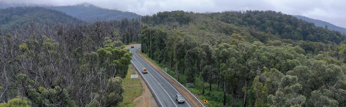
Transport for NSW has delivered a $20 million program of efficiency upgrades on the Kings Highway to keep the community safe and freight moving between Batemans Bay and the NSW/ACT border.
Latest news
August 2025 – Safety improvements south-east of Braidwood complete
Transport has delivered the final safety improvement project under the Kings Highway upgrade program south-east of Braidwood.
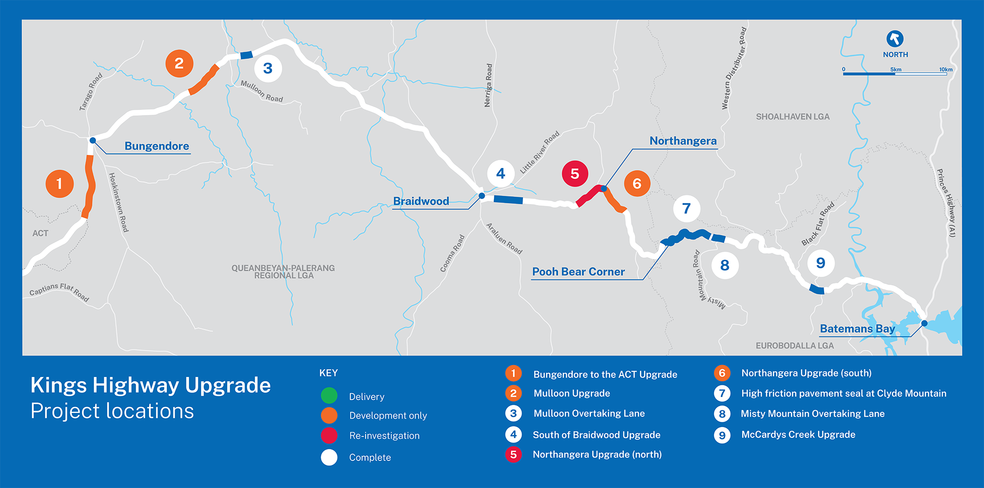
Development will continue on the following projects under the Kings Highway upgrade program, for future funding opportunities:
- safety improvements between Bungendore and the ACT border
- safety improvements west of Mulloon Road
- safety improvements south of Northangera Creek Bridge.
The site north of Northangera Creek Bridge may be revisited in future planning as needs and priorities are reassessed.
View larger version of map (PDF, 222.33 KB).
Subscribe for updates on works planned along the Kings Highway.
Project information
Background
The NSW Government committed $20 million to deliver a program of safety and efficiency upgrades on the Kings Highway.
The Kings Highway links the Australian Capital Territory (ACT) with the NSW South Coast via Bungendore, Braidwood and Nelligen. Within NSW, the Kings Highway is approximately 128 kilometres long and it serves as a primary link to the NSW South Coast for traffic from the ACT and the Snowy Monaro region. The Highway travels through the Queanbeyan-Palerang Regional Council and Eurobodalla Shire Council local government areas.
Transport for NSW rescoped the deliverable projects under the $20 million Kings Highway upgrade program after preliminary development confirmed funding allocation constraints. Five projects have been delivered under the program with three projects moving to development only and one project to be reinvestigated. Additional construction funding will be sought for development-only projects from alternate programs in the coming years.
The upgrade program has delivered:
- a new eastbound overtaking lane at Mulloon
- a new eastbound overtaking lane near Misty Mountain Road
- safety treatments including widened centrelines, widened shoulders, roadside safety barrier, and audio-tactile line marking north of McCardy's Creek
- high-friction pavement seal on parts of ‘Clyde Mountain’ to reduce the likelihood of wet weather crashes
- roadside safety barrier along the southern approach to Braidwood
The below projects will be developed as delivery ready projects for future funding opportunities:
- safety treatments including widened centrelines, widened shoulders, roadside safety barrier, and audio-tactile line marking at the following locations:
- between Bungendore and the ACT border
- west of Mulloon Road
- south of Northangera Creek Bridge
The site north of Northangera Creek Bridge may be revisited in future planning as needs and priorities are reassessed.
The overall program was completed in August 2025.
Benefits
This project is aligned to safety and performance outcomes of Future Transport 2056 as it intends to provide customers with a safer road network and improve the efficient mobility and access of general traffic and road-based public transport along the Kings Highway in terms of improving travel times and level of service.
Future Transport 2056 was released in March 2018 and two of its key objectives will be supported by the program by:
- enhancing the ‘hub and spoke’ transport network for the Global Gateway City of Canberra, as well as the strategic centres of Queanbeyan and Batemans Bay
- adopting a Safe Systems approach to the delivery of road safety improvements on the Kings Highway which will directly contribute to achieving the ‘Towards Zero’ target
- upgraded sections of the Kings Highway targeting an AusRAP rating of 3-stars or higher, which is expected to have a 60 per cent reduction in fatal and serious injury crashes and help realise the Towards Zero outcome from NSW Road Safety Plan 2021.
AusRAP is part of a globally recognised Road Assessment Program (RAP). It is used to assess road attributes that are known to have an impact on the likelihood and severity of a crash. Star assessments range from 1 – 5. Road safety treatments such as separation of opposing traffic by a wide median, audio tactile line marking, sealed shoulders and roadside barrier to protect from hazards such as trees, poles and embankments close to the roadside are measures to increase star ratings and improve road safety.
Overtaking lanes can improve journey time and user experience. The new overtaking lanes will enable safer passing opportunities and reduce the risk of crashes. This will help support regional economic growth by promoting tourism and freight traffic on the Kings Highway.
McCardy's Creek safety improvements
Safety improvements at the intersection on the Kings Highway near McCardys Creek were completed on Tuesday 27 September 2022. The project took place at two locations on the Kings Highway, and included the following:
- Site A - Shoulder widening on the westbound shoulder 50 metres from the intersection, including full westbound slow lane resurfacing. Work will also include the installation of stormwater drainage, 300 metres of flexible roadside barrier and new signage
- Site B - On the westbound shoulder the existing flexible roadside safety barrier was extended by 40 metres eastbound.
By upgrading sections of the corridor to the improved 3-Star AusRAP target, these safety improvements will reduce the frequency of fatal and serious injury crashes on the Kings Highway. They will also improve corridor efficiency for all road users and enhance corridor resilience.
Misty Mountain Road eastbound overtaking lane
The new eastbound overtaking lane on the Kings Highway was completed on Thursday 25 January 2024.
In addition to the new 660 metre overtaking lane, the project delivered curve realignment, road shoulder widening, audio tactile line marking and the installation of safety barrier.
The projects aim is to contribute to the overall KHUP program objectives of:
- reducing the frequency of fatal and serious injury crashes on the highway through upgrading sections of the corridor that have existing 1 or 2-Star AusRAP ratings to target 3-Star ratings
- enhancing corridor resilience to road incidents, natural hazards and during emergency situations
- improving corridor efficiency for all road users through reduction in journey times and costs
The right turn into Misty Mountain Road from the new eastbound overtaking lane will also be permanently removed for the safety of transport customers.
Mulloon eastbound overtaking lane
The new 760 metre eastbound overtaking lane on the Kings Highway at Mulloon was completed on Friday 12 December 2024.
The project included the delivery of an eastbound overtaking lane, road shoulder widening, upgraded drainage structures, audio tactile line marking and the installation of roadside safety barrier.
The project aims to contribute to the overall Kings Highway upgrade program objectives of:
- reducing the frequency of fatal and serious injury crashes on the highway through upgrading sections of the corridor that have existing 1 or 2-star AusRAP ratings to target 3-star ratings
- enhancing corridor resilience to road incidents, natural hazards and during emergency situations
- improving corridor efficiency for all road users through reduction in journey times and costs.
Braidwood south safety improvements
Safety improvements on the Kings Highway from 400 metres east of Monkittee Street to 500 metres West of Clarevale Lane, south of Braidwood, was completed on Friday 15 August 2025. The project delivered:
- Roadside safety barrier installed along both sides of the Kings Highway. While the project site spanned a three-kilometer length, gaps have been provided in the roadside barrier for property accesses and at select locations to enable pullovers and emergency stopping.
The minor works REF has been published and can be accessed on the Regional Projects - Environmental Assessments page.
Frequently asked questions
What are the details of the project?
To improve the safety of motorists on the Kings Highway, roadside safety barrier has been installed on the southern approach to Braidwood to protect motorists from the risk of colliding with the avenue of poplar trees.
Why are we doing the project?
The current avenue of trees is located close to the travel lane at this location. This project aims to protect motorists from runoff road crashes, where vehicles veer off the road and collide with objects, such as a tree or culvert (large drainage pipe).
To achieve the ultimate goal of zero deaths and serious injuries on NSW roads, the Safe System Approach to road safety has been adopted. The System is supported by key principles that work together to prevent fatal and serious injury crashes. Installing roadside barriers aligns with this approach, by reducing the severity of run off road crashes should they occur.
Why are we using guardrail?
Guardrail safety barrier protects motorists from roadside hazards and helps reduce the severity of a crash.
The installation of safety treatments north of Braidwood in May 2020 identified strong community support for the avenue of trees at the entrance points of Braidwood to remain.
Advancements in roadside barrier technology have reduced the amount of deflection required behind the guardrail, meaning the avenue of trees can be safely protected by barrier without having to be removed.
What safety improvements have already been implemented in this location?
In 2013, the speed limit within the project area was reduced from 100 km/h to 80 km/h to reduce the risk of high-speed crashes. This was an initial solution to improve road safety while also allowing the trees to remain.
The Safe System Approach is supported by key principles that work together to prevent fatal and serious injury crashes. While Safe Speeds is one of those principles, the system also includes the principle of Safer Roads. Installing roadside barriers aligns with this approach, by reducing the severity of run off road crashes should they occur.
Why are the trees important?
The trees were planted to celebrate the 25th year of King George V's reign and are a heritage feature of Braidwood. Consultation in 2011 noted the community highly valued the avenue of poplars decorating the entrances of Braidwood. The trees have been assessed by the Office of Environment and Heritage as a heritage feature of Braidwood to be maintained.
Will the avenue be maintained into the future?
The trees have been assessed by the Office of Environment and Heritage as a heritage feature of Braidwood to be maintained.
However, the original golden poplar trees are aging, and the management of the avenue will continue to be monitored as they reach the end of their natural lives.
While there are no plans to remove or replace the avenue of trees at this location, Transport will continue to work with the Office of Environment and Heritage and Queanbeyan Palerang Regional Council to ensure the community and the travelling public are safe.
Community notifications
Media releases
- June 2025 - Final stages of upgrades on the way for the Kings and Monaro Highways
Start of work announcement for the safety improvement project south-east of Braidwood. - December 2024 - New overtaking lane now open on the Kings Highway
Completion announcement for the new eastbound overtaking lane at Mulloon. - January 2024 - New eastbound overtaking lane at Misty Mountain open
Completion announcement for the new eastbound overtaking lane at Misty Mountain. - August 2023 - Work starts on new Kings Highway overtaking lane
Start of work announcement for the new eastbound overtaking lane at Mulloon.
Contact us
For further information about this project, please contact:
Email: SouthProjects@transport.nsw.gov.au
Mail: Kings Highway upgrade program, PO Box 477, Wollongong NSW 2500