Kings Highway Road Safety Review
Project overview
In 2012 the NSW Centre for Road Safety and Roads and Maritime Services carried out a route safety review of 117 km of the Kings Highway between the Princes Highway roundabout at Batemans Bay and the eastern most part of the ACT border just north of Bungendore.
Project information
Background
After consultation with the community the Kings Highway safety review (PDF, 3.49 MB) was finalised and released in March 2013.
The report recommends that road safety outcomes would be best achieved by implementing a combination of engineering, behavioural and police enforcement programs.
The review investigated:
- Fatal and injury crashes
- Road safety engineering issues
- Current speed limits and speed zones
- Driver behaviour issues such as speeding, drink driving and driver fatigue
- Heavy vehicle issues.
Community members and stakeholders were invited to submit their feedback on the review through an online issues mapping tool, in community workshops and by email and post.
Feedback was collected on:
- Locations on the Kings Highway where road safety is a problem
- Locations of near miss or unreported accidents
- General road safety concerns on the Kings Highway
- The proposed treatments for the Kings Highway near Braidwood
As part of the consultation process a community workshop was held in both Bungendore and Batemans Bay.
As a result of the safety review, Roads and Maritime Services developed an ongoing strategy of safety programs and works for the Kings Highway. A number of projects have been completed, and others are underway.
Safety improvements
Road safety engineering works including upgrades and improvements to:
- Clear zones
- Road alignment
- Speed zones
- Line marking
- Signage
- Road intersections and junctions
- Road shoulders
- School bus facilities
- Overtaking lanes.
Road user behaviour programs targeting:
- Speeding drivers
- Driver fatigue, distraction and inattention
- Drink drivers
- Road user information
- Police and Roads and Maritime Service enforcement.
Increasing the current enforcement program targeting:
- Speed enforcement
- Speed camera enforcement
- Driver fatigue and drink driving education.
Enhanced road safety engineering works
Clear zone hazard management
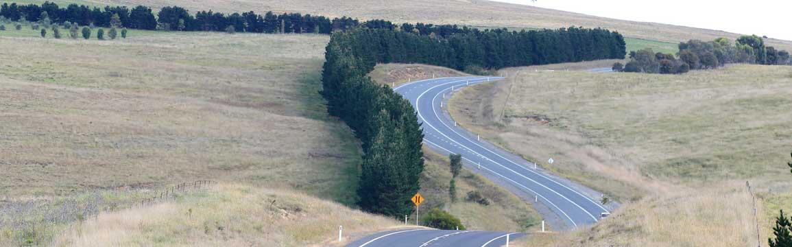
A clear zone is an area next to the road that is either free of, or protected from, roadside hazards such as trees, steep drop-offs and drainage culverts. An effective clear zone minimises the risk of harm to road users who unintentionally veer off the road. Ideally, clear zones would be free or protected from hazards within five metres of the edge of the road pavement.
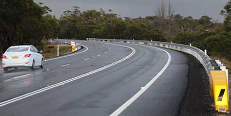
Roads and Maritime is improving clear zones along the Kings Highway. Where a hazard free clear zone cannot be provided, safety barriers have been installed as an alternative measure to protect road users.
Delineation (lines and signs) improvements
Effective delineation improves the efficiency and safety of the existing road system by improving driver information, driver comfort and traffic flow.
Line marking, reflective road pavement markers and guide posts, curve warning signage and advisory speed signage are all examples of delineation devices that are used to help guide road users.
As well as reviewing delineation along the entire route, Roads and Maritime is looking specifically at the effectiveness and consistency of line marking at junctions and at the placement of overtaking opportunities so that adjustments in line marking can be made to enhance safety.
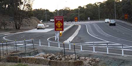
Upgrades to road signage
Warning signs provide road users with information to guide them and give advance warning about the road environment ahead. Accurate and consistent signs also provide advance information about road and weather conditions and directions.
Roads and Maritime installed vehicle activated signage at three locations at Clyde Mountain. The signs are placed at one eastbound and two westbound locations and activate to flash a 'curve warning' message if a motorist is travelling faster than the advised speed.
Signage upgrades will help reduce speed related incidents on the Highway by better identifying changes in the road environment and advising road users of the appropriate speed for conditions on the road ahead.
Roads and Maritime will continue to assess and improve signage along the entire length of the highway as part of this program.
Review of speed zones
Speed limits are set in accordance with speed zoning guidelines. The guidelines state that speed zones should be consistent and logical, reflecting the type of environment the road passes through. Drivers should be able to determine the speed limit from cues in the roadside space rather than relying on regulatory speed signs. Changes in speed limit should be minimised to avoid confusion, and should apply to a significant length of road, rather than as a treatment for a particular hazard.
A full speed zone review will be undertaken toward the completion of the road safety upgrades to ensure consistency of the speed zones along the route. Road work speed limits should be expected over the course of the three year safety program and are enforceable.
School bus facilities
Having easily identifiable and consistent bus facilities along the Kings Highway is essential to ensure the safety for motorists and children.
As part of the Kings Highway program of work, Roads and Maritime will work with the community to identify appropriate locations where school busses can pick up and set down children clear of highway traffic.
Improving road shoulders and road alignment
Providing wide sealed shoulders can help reduce serious incidents by allowing road users more time to regain control should their vehicle leave the travel lane for any reason. Where possible, correcting poor road alignment features such as sharp curves or dips and crests in the road can also help improve road safety, especially in wet weather.
Roads and Maritime has identified a number of sections where the road shoulders, pavement and alignment can be improved and provide enhanced road safety outcomes. Work has been completed on sections east of Larbert Road and at Doughboy, and is underway east of the Shoalhaven River and at River Forest Road.
Contact us
For further information about this project, please contact:
Email: southprojects@transport.nsw.gov.au