Nowra Bridge project - Princes Highway upgrade
Project overview
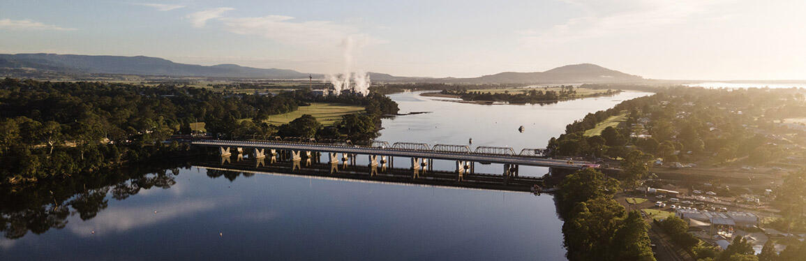
The Nowra Bridge project has provided a new four lane bridge over the Shoalhaven River, upgraded intersections and additional lanes on the Princes Highway. Major work started in mid-2020 and the new bridge was opened to traffic in February 2023. Finishing work on the project was completed in October 2024.
Latest news
June 2025 – Night work on the Princes Highway and Illaroo Road
We will be carrying out maintenance work on the Princes Highway and Illaroo Road to improve safety for motorists. Work involves minor concrete repairs and installing new line marking and signage on the Princes Highway, at the intersection of the Princes Highway and Illaroo Road, and on Illaroo Road up to the intersection with Fairway Drive.
Work will be carried out at night, between 7pm and 6am on Monday 30 June 2025, weather permitting.
Traffic control, lane closures and a reduced speed limit of 40 km/h will be in place during work.
We will make every effort to minimise impacts and complete this work as quickly as possible.
November 2024 – Finishing work complete
Finishing work for the Nowra Bridge project was completed in October 2024.
Over the last six months, we have carried out the following work to complete the project:
- landscaping across the project has been finished and landscape maintenance is underway
- completing footpaths across the project
- removing the site compounds and restoring ancillary sites
- removing excess spoil from the Bolong Road stockpile site
- removing and replacing contaminated mulch from several locations across the project area.
We would like to sincerely thank the community for all their patience throughout construction of the new Nowra Bridge over the last four years.
With work on the new bridge now complete, our focus will now move to repurposing the historic Nowra Bridge into a dedicated pedestrian and cyclist path. View the Historic Nowra Bridge repurposing page to find out more about this work.
Operational noise assessment
In 2018, the Nowra Bridge project’s Review of Environmental Factors predicted the operational road traffic noise emissions for the new bridge.
To validate the initial assessment and verify compliance with relevant environmental obligations, we have completed a post-construction operational noise assessment for the new bridge.
View the Post-Construction Operational Noise Assessment (PDF, 24.69 MB).
Project information
Background
The Nowra Bridge project has provided a new four lane bridge over the Shoalhaven River, and upgrades to over 1.7 kilometres of the Princes Highway, including improved intersections and additional lanes.
The project has improved traffic flow and eased congestion on a major section of the Princes Highway, and delivers safer, more reliable journeys within the Nowra-Bomaderry area.
The new Nowra Bridge was opened to traffic in February 2023 and major construction work was completed in November 2023. Finishing work on the project was complete in October 2024.
The need to build a new bridge across the Shoalhaven River was identified due to the poor condition, significant maintenance costs, and weight and size limits of the historic Nowra Bridge.
The historic bridge was retired from road traffic use after the new bridge was opened in February 2023. View the Historic Nowra Bridge repurposing page to find out more about the future of the historic bridge.
Frequently asked questions
Community consultation
How was the community involved in the development of the project?
The community has been consulted on the development of the Nowra Bridge project since 2013 during the investigation phase when we introduced the project and sought feedback on several potential locations for a new bridge.
In 2014, the community was invited to provide feedback on the recommended location for the bridge. We received a largely positive response from the community about the recommended option and also noted that there was a strong expectation from the community that the project should address traffic issues at the Bolong Road, Illaroo Road and Bridge Road/Pleasant Way intersections.
In early-2018, following further investigations, we consulted the community on the preferred option. During the consultation period, we received 84 written submissions and 250 online and written surveys. Of the written submissions received, one submission was received from Shoalhaven City Council and 83 submissions were received from community members, interest groups, transport providers, local businesses, and government agencies. This feedback was used to further refine the project design and inform the environmental assessment of the proposed Nowra Bridge project.
The Review of Environmental Factors (REF) was publicly displayed in mid-2018 and 109 responses were received during the display period. Most submissions were received from the community, including individuals, businesses, and community groups. Submissions were also received from Shoalhaven City Council, Department of Primary Industries (Fisheries), NSW Environment Protection Authority, Office of Environment and Heritage, and Natural Resources Access Regulator.
In response to submissions from the community and following further design development after the display of the REF, changes to the REF and detailed design occurred. A report detailing the submissions received was published in 2019.
Construction
How was the new bridge built?
The new four lane concrete bridge is around 360 metres long and is located upstream (west) of the existing bridges. The new concrete bridge carries northbound traffic, and the existing concrete bridge (opened in 1981) is now used for southbound traffic.
Thirty-nine steel piles were driven into the riverbed, and the new bridge has nine piers across the river to match the existing bridges. Nineteen concrete double-T deck segments were cast on the southern side and were incrementally launched across the river until they reached the northern foreshore.
Due to the varying depth of water across the Shoalhaven River at this location, different construction methodologies were used.
Across the southern half of the river where water is shallow, a temporary rock platform provided a working area for bridge piling and foundation works. The rock platform extended around 130 metres into the river and was about 45 metres wide.
A silt curtain was installed in the area and became operational before any rocks were placed in the waterway.
Across the northern half of the river, where the depth increases to around nine metres, work to install the piled foundation was carried out from barges and boats.
What was the cost of the project?
The $342 million Nowra Bridge project was jointly funded by the Australian and NSW governments.
In 2024, the project received additional funding from the Australian and NSW governments for work near the Bolong Road intersection and the repurposing of the historic Nowra Bridge. The total funding for the project is now $364 million.
How long did the project take?
Fulton Hogan Construction was awarded the design and construction contract and work started in 2020.
The new bridge was completed and opened to traffic in February 2023, with major construction work finished in November 2023.
Final work on the project was completed in October 2024.
Why was a temporary rock platform constructed?
The river is too shallow on the southern side to allow the use of a large barge for piling works. The temporary platform allowed the piling rig, crawler cranes and other heavy plant and equipment to operate safely to build the new bridge.
Although a large part of the river’s width was restricted, the main channel and deep water was unobstructed by the rock platform, so there was minimal effect on river and tidal flows. The temporary rock platform was removed from the river after bridge construction was completed and some of the material was reused elsewhere on the project.
What is piling and why was it required?
Piles create a strong foundation for the bridge by connecting the piers to a layer of soil or rock. The piling method used depends on the soil or rock type and the load the pile will support.
The northern-most pier was constructed using bored piles filled with concrete. This method is used as the depth to rock is around 10 metres. Driven piles were required at all other piers across the river where the depth to rock is up to 60 metres.
Driven piles are built by driving tubular steel cases into the ground using a large hammer on a piling rig. The piles are vibrated into the sediment and then driven by a hammer into the rock deep below the riverbed.
Why was the intersection of Scenic Drive and Bridge Road closed to traffic?
The intersection of Scenic Drive and Bridge Road was closed in September 2020 to provide a safer working area during construction. The main bridge compound was located on Scenic Drive and there were daily heavy vehicle movements in the area.
Following completion of major work on the project, the intersection remained closed and has become a cul-de-sac for safety reasons. This was included in the detailed design.
With the new bridge built on the western side of the existing bridges, the highway has also shifted west. If retained, the Scenic Drive and Bridge Road intersection would have been too close to the new pedestrian crossing on Bridge Road. Vehicles turning left out of Scenic Drive would have limited sight and stopping distance to pedestrians.
The right turn into Scenic Drive was also removed due to insufficient queuing area on Bridge Road which would have caused traffic and safety issues on the Princes Highway.
For more information view the Scenic Drive animation.
Why was vegetation removal required?
Removal of vegetation at Moorhouse Park, Scenic Drive, and other areas was required to make space for temporary work compounds and storage areas.
Vegetation removal also occurred where power, water or other services were relocated. The project aimed to minimise vegetation loss and reuse material across the project where possible.
Habitat boxes for animals and birds were installed in neighbouring Nowra woodland in 2020 to offset impacts from vegetation loss.
Has water quality in the Shoalhaven River been affected?
Water quality was assessed and water quality controls were outlined for the construction and operation of the Nowra Bridge project.
A Soil and Water Management Plan was prepared and included in the project’s Environmental Management Plan addressing construction risks such as soil erosion and resulting sedimentation of the Shoalhaven River and Bomaderry Creek, as well as fuel and other chemical leaks from plant and equipment.
The design included water quality basins to treat stormwater runoff from the new northbound bridge.
Stormwater from the local road improvement works has been directed into the existing stormwater system.
Were local employment and businesses used during the project?
All expressions of interest for employment on the Nowra Bridge project were considered on a case-by-case and as-needs basis. Several local sub-contractors and suppliers from the Shoalhaven region were engaged throughout construction. A competitive tendering process applied to all packages of work as is standard practice with large projects.
Detailed design and urban design
What is the final design of the project?
Key features of the final design include:
- upgrades to over 1.7 kilometres of the Princes Highway to provide at least three lanes in each direction between Mattes Way and Moss Street
- a new four lane bridge for northbound vehicles, with the existing bridge (built in 1981) reconfigured to provide three lanes for southbound vehicles
- two right turn lanes into Illaroo Road from the Princes Highway, and three lanes turning right and one dedicated left turn lane onto the highway
- two longer lanes for road users turning right into Bridge Road and retention of the dedicated left turn lane from Bridge Road to the Princes Highway to travel north
- left turn only into Pleasant Way and a new local road built further south to connect the Princes Highway to Lyrebird Drive permitting left in and left out access
- a new roundabout on Illaroo Road at the Fairway Drive intersection to provide safe access to and from the northern foreshore
- closure of the intersection of Scenic Drive and Bridge Road to improve pedestrian safety and connectivity
- improved pedestrian and cyclist connectivity across the project including a new 3.5-metre-wide shared path on the new bridge.
How does the Nowra Bridge project improve traffic flow?
With the new bridge open, three lanes of traffic now flow in each direction over the river, with an additional left turn lane into Illaroo Road for northbound traffic.
All traffic lights have been coordinated and optimised within the project area and further south through Nowra. Bolong Road, Illaroo Road, and Bridge Road intersections now allow for all traffic movements to improve traffic efficiency on the Princes Highway.
We recognise the community is interested in peak holiday season traffic volumes. Overall, the additional lanes, improved intersections, and optimised traffic lights improve capacity and reduce congestion on the highway and surrounding local roads.
The traffic modelling for the project considered traffic growth up to the year 2046.
How has the project improved pedestrian and cyclist access?
There is improved pedestrian and cyclist access across the project. A 3.5 metre wide shared path on the western side of the new northbound bridge connects to 2.5 metre wide paths elsewhere across the project.
The project also improves east-west connections across the Princes Highway for pedestrians and cyclists by providing additional signalised crossings at the Bolong Road intersection as well as shared path underpasses at the southern foreshore, and a pedestrian stairway and path under the bridges on the northern side of the river.
What is the urban design and landscape plan?
The urban design and landscape plan shows how the new bridge connects with its wider environment. We considered the existing natural landscape, strategic plans for the Shoalhaven River foreshore and Nowra CBD, and the historic Nowra Bridge.
Was a bypass of Nowra considered?
An additional four-lane bridge on the Princes Highway over the Shoalhaven River was determined as the most effective way to improve traffic efficiency and reduce traffic delays on the Princes Highway between Nowra and Bomaderry.
A wide range of detailed investigations were carried out to identify how to achieve this, including a bypass. However, traffic studies identified about 85 per cent of trips across the bridge have their origin and destination in the Nowra or Bomaderry area and would not use a bypass.
Construction of the new four-lane bridge does not preclude the planning of a future bypass. View the Nowra bypass and transport improvements page to find out more about plans for a potential future bypass of Nowra.
Was a flyover or underpass considered at the Illaroo Road or Bridge Road intersections?
Grade-separated intersections were assessed extensively during the development of the design.
This included assessing how grade-separated intersections would impact traffic flow on the Princes Highway and the local road network, as well as the environmental impact.
An assessment of 11 grade-separated options was carried out for the proposal. The traffic modelling identified that many combinations of grade-separated intersection options on the northern and southern sides would introduce inefficient and unsafe weave, merge and queuing issues that did not exist on the network.
While these would provide benefits to the local road network, they had the highest level of congestion on the Princes Highway compared to the other network options that were modelled.
Historic Nowra Bridge
What will happen to the historic Nowra Bridge?
The historic Nowra bridge has reached the end of its serviceable life for road traffic and was retired from use when the new Nowra Bridge opened to traffic in February 2023.
The future of the historic bridge has been the subject of extensive investigations, with community feedback showing a strong desire for the bridge to be retained. In 2018, it was decided the bridge would be retained and repurposed as a dedicated pedestrian and cyclist path.
The decision was based on the historical significance and heritage value of the bridge, while also considering the expected benefits to the area as well as community feedback.
Before the historic bridge moves into its next phase of life, essential maintenance work is required to make the bridge safe for pedestrian and cyclist use.
Work to repair and repurpose the bridge will be caried out in four stages, with the full program of work expected to take around two to three years to complete, weather permitting.
When is work starting on the historic bridge?
The first stage of work began in November 2024 and is expected to take around six months, weather permitting.
Work will involve critical repairs to damaged and degraded steel elements of the bridge, removal of the attached cantilevered footpath, prioritised repainting of the bridge, and installation of lighting and other additional features so the bridge meets current safety standards suitable for use by pedestrians and cyclists.
How can I find out more?
View the Historic Nowra Bridge repurposing page to find out more about the repurposing work and subscribe for future updates.
Image
Image controls:
Media releases
Contact us
For further information about this project, please contact:
Phone: 1800 555 638
Email: NowraBridgeProject@transport.nsw.gov.au
Mail: PO Box 477, Wollongong NSW 2520