Wilson Street Cycleway
Project overview
We’re providing an important connection in our bike network to make it easier and safer for people riding bikes. The NSW Government is proposing to build a new cycleway on Wilson Street in Newtown, between Eliza Street and east of Erskineville Road.
The missing link would connect bike riders between Newtown, Redfern and the city centre and help make Wilson Street safer for everyone using the street.
Improved crossings and resurfaced road will also improve journeys for people walking and driving.
Latest news
September 2025 – Have your say
To progress the proposal, a Review of Environmental Factors (REF) has been developed and is now available for public display.
An REF is an environmental assessment used to determine potential impacts associated with the proposal. Displaying the REF provides an opportunity for the community and stakeholders to make a submission prior the proposal being determined.
Submissions can be made via email, online feedback form, or by post (see address below). Submissions are open until 11.59pm on Friday 24 October 2025.
You can view the REF at the bottom of this page or get in touch with our team to request a copy.
Project information
Project background
More people are choosing to walk or ride a bike – and it’s easy to see why. It’s healthy, good for the environment, and can be a great way to get around.
To support this shift, the NSW Government is investing in better active transport infrastructure so everyone – including kids riding to school, parents with prams, or people with disability – can move around their communities safely and easily.
Newtown is one of Sydney’s most vibrant suburbs, known for its local shops, art, and great food. The existing Wilson Street Cycleway and its connections offer bike riders a scenic route through the area, linking places like Carriageworks, nearby parks, and entertainment precincts at Moore Park. It’s an important part of Sydney’s growing bike network.
That’s why Transport for NSW is proposing a new two-way separated cycleway along Wilson Street, to provide the missing link between the shared zone on Eliza Street and the existing one-way cycleway on Wilson Street, east of Erskineville Road.
Right now, bike riders share the road with cars and buses on this section, which can be challenging and feel unsafe, especially for those who are less confident or new to bike riding.
A separated cycleway would make riding safer and easier for everyone and may encourage more people to choose riding between Newtown, Redfern, and the city centre.
In 2024, we asked the community for feedback on the initial design. We thank everyone who shared their views as it’s helped us further refine the design.
In early 2025, the project received delivery funding from the Australian Government in partnership with the NSW Government. The Australian Government is contributing through its Active Transport Fund, which invests in projects that provide more opportunities for people to safely walk and cycle through their communities.
We’ve now updated the design and prepared a Review of Environmental Factors (REF) for further community feedback.
Project benefits and key features
Benefits
- Connecting the dots: it would create a safe and direct link for bike riders in an important east-west bike route between Newtown, Redfern and the city
- Safer riding for everyone: dedicated bike lanes, separated from car traffic, would make riding safer and easier no matter your age or ability
- Pedestrian safety: a new signalised crossing would make it safer for people to cross the road at Eliza Street and there will be fewer people riding on the footpath along the route
- Encouraging people to ride: riding a bike is great way to make short trips, boost physical and mental health, and enhance social connections
- Improved communities: more people riding helps to reduce noise, air pollution, and traffic congestion, making the area a more enjoyable place to live and visit
Key features
- Two-way separated cycleway on the northern side of Wilson Street
- Signalised pedestrian crossing at Eliza Street
- Raised bike crossing on Wilson Street
- Road resurfacing, line marking and speed hump
Following community and stakeholder consultation last year, we’ve made some design changes including:
- New loading zone on the western side of Erskineville Road (between King Street and Wilson Street)
- Improved signage along the cycleway
- Removal of the left turn from Wilson Street (eastbound) into Erskineville Road for motorists
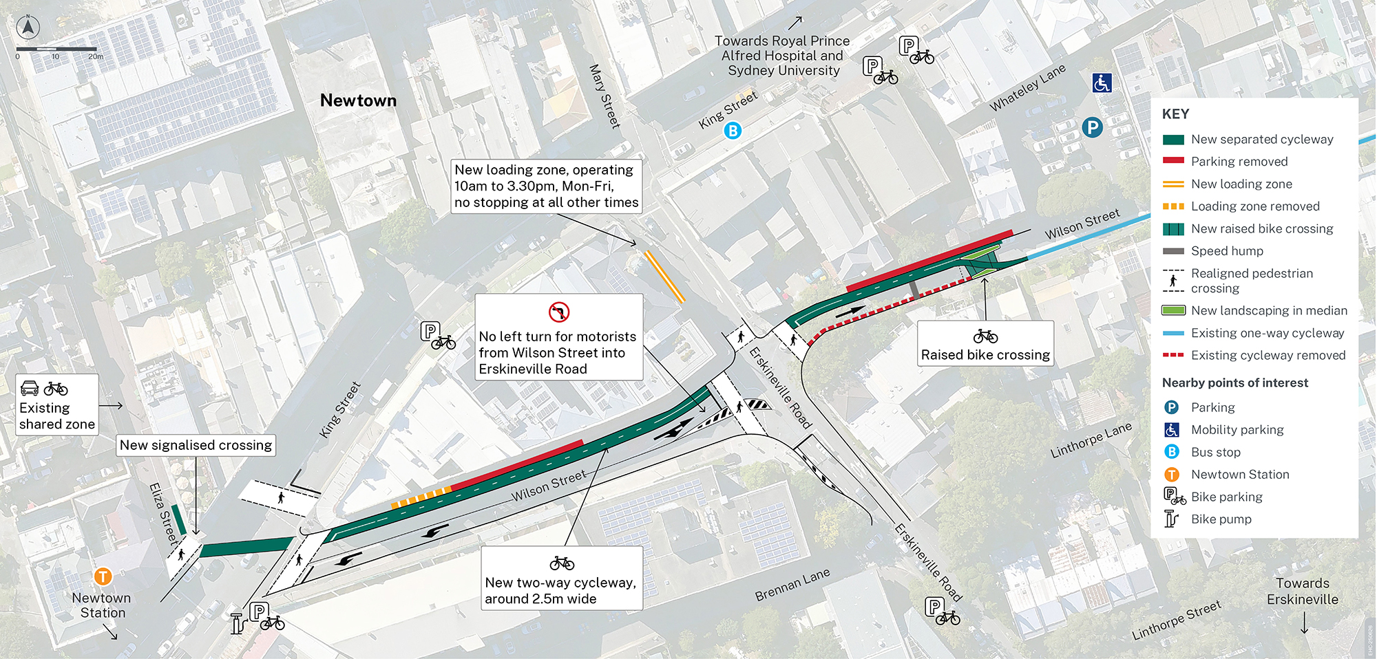
View larger version - map of key project features (PDF, 5.94 MB)
Parking and loading zone changes, access for drivers and bike riders
Parking and loading zone changes
The proposal would require the removal of 13 parking spaces and a loading zone on Wilson Street. This includes:
- 6 spaces with 30-minute timing
- 7 spaces which are untimed
- 1 loading zone (approximately 12 metres long), from 9.30am to 6pm Monday to Friday, with no stopping from 6.30am to 9.30am Monday to Friday.
Whilst we aren’t able to replace the removed parking spaces, there are nearby options which include the Council carpark off Wilson Street.
The community can also use local public transport options including trains and buses.
Based on community feedback, we assessed new loading zone options close by, considering impacts on the road, public transport, parking, and proximity to businesses.
The preferred option is to install a new loading zone, around 12 metres long, on Erskineville Road between King Street and Wilson Street, operating 10am to 3.30pm, Monday to Friday. Currently, this area is a no stopping zone at all times.
The map below shows the approximate location of proposed changes to parking and loading, including a new loading zone and nearby alternative options to park or load.

View larger version - proposed parking and loading zone map (PDF, 8.05 MB)
Changes to access for drivers
The left turn from Wilson Street (eastbound) into Erskineville Road (northbound) would be removed for motorists to improve safety for people walking and cycling.
For more information, you can read the alternate route assessment for motorists in the REF.
Cycling access to surrounding streets
- bike riders on the cycleway travelling westbound from Redfern and wanting to head southwest on King Street (towards Newtown Station) should turn right on Erskineville Road, then left onto King Street
- bike riders on the cycleway travelling westbound from Redfern and wanting to head south on Erskineville Road (towards Erskineville Station) should turn earlier down Burren Street
- bike riders on the cycleway travelling eastbound from Stanmore and wanting to head south on Erskineville Road (towards Erskineville Station) should either continue east and turn right at Burren Street or join the traffic lane
- bike riders on Eliza Street travelling southbound wanting to head southwest on King Street (towards Newtown Station) should cross further west on King Street.
For information on cycle routes in your area, visit the Transport Cycleway finder, or City of Sydney and Inner West Council websites.
The map below shows the turning movements as part of the new cycleway.

View larger version - proposed cycleway map (PDF, 627.29 KB)
Bike crossing
A new raised crossing would provide bike riders with a safe place to cross from the existing one-way cycleway to the new two-way cycleway. Motorists would need to give way to bike riders using the crossing. Pedestrians would need to use the crossing at Erskineville Road.
There would be clear signage provided to direct bike riders using the cycleway.
Waste collection
We’re working with all stakeholders to make sure the cycleway design supports safe, practical, and uninterrupted waste collection for everyone on Wilson Street.
Southern side of Wilson Street (between King Street and Erskineville Road)
No changes. The proposed cycleway does not affect this side of the street, and bin collection would continue as usual.
Northern side of Wilson Street (between King Street and Erskineville Road)
Bins would still be placed on Wilson Street as they are now. The only change is that collections would happen outside regular hours, as per the City of Sydney’s policy for waste collection across cycleways. This approach is already in place across other cycleway locations and helps ensure safety for both waste crews and the community.
Residential collection
There would be no change to residential collection.
Cycleways and waste collection
As cycleways expand across Sydney, scheduling waste collection during low-traffic periods has become standard practice. This helps protect waste crews and ensures smooth movement for pedestrians, cyclists, and drivers alike.
Potential construction impacts
Construction is estimated to take around 11 months, depending on weather and site conditions, and we’ll look to stage the work to reduce disruption.
During our work, there would be some temporary impacts. We’ve summarised the key ones here, however you can read more in the REF:
- Reduced speed limits, partial lane closures with detours
- Progressive removal of parking and loading zone during construction
- Temporary disruptions to vehicle access to several properties, for activities such as road re-sheeting work (access to properties and businesses would be maintained)
- Closure of existing footpaths and parts of the cycleway, with detours for bike riders and pedestrians
- Trucks, equipment and workers in the area
- Visual impact from construction machinery, fencing, and the site office and compound (we’ll provide information on the location of these before construction).
Work hours, noise and vibration
- We would work mostly at night to minimise road network impacts and ensure worker safety
- Night work hours would be 8pm to 5am, Sunday to Thursday (no work on public holidays)
- Some daytime work may be required
- Night-time construction noise is expected, particularly from activities like demolition of existing concrete kerbs, road re-sheeting and utilities work
- Vibration is also expected from activities such as rolling the road surface.
Detailed plans for construction would be developed with the delivery partner and the community would be notified before work starts.
Have your say and meet our team
Your feedback is important to help make this a great project for the community.
Provide your written feedback by:
- Email: cbd-and-east@transport.nsw.gov.au
- Online feedback form
- Post: Transport for NSW Wilson Street Cycleway Project
Sydney Integration and Place team
PO Box K659, Haymarket NSW 1240
Feedback is welcome until 11.59pm Friday 24 October.
If you require a printed version of the REF, please contact our team.
Community pop-up sessions
Drop by one of our community pop-up sessions to learn about the proposal and ask questions.
Newtown Station, King Street (outdoors):
- Wednesday 24 September, 3pm to 5pm
- Saturday 18 October, 10am to 12pm
We’ll be located near the station entrance, off King Street. In case of adverse weather, the outdoor session may need to be cancelled. Please check our website for the latest updates or contact our team using the details below.
We’re also holding a community drop-in session.
Newtown Neighbourhood Centre – Gadigal Hall, 11-13 Darley Street, Newtown:
- Thursday 16 October, 5pm to 7pm
For accessibility questions, please contact our team.
Business engagement
Local businesses are invited to attend an individual session with our team. We’ll be in touch with details, or you can contact us directly.
Next steps
We will consider all feedback from the public display period and prepare a submissions report with our responses. It will be available on our project webpage and emailed to subscribers.
Pending planning approval and consultation, construction work is expected to start in 2026.
Project steps
- initial design developed
- community consultation
- environmental assessment prepared (REF)
- community consultation - We are here
- design completed and construction planning
- construction starts
- work is complete.
Frequently asked questions
How many people use the existing Wilson Street cycleway?
The City of Sydney manages the existing cycleway along Wilson Street. According to their March 2025 count data, an average of around 830 cyclists used Wilson Street daily at the intersection with Erskineville Road.
Twice a year City of Sydney carry out cycling count surveys to provide an analysis of cycling trends across the local area. The counts take place at around 100 locations in fair weather conditions, on a weekday in March and October. Read more on their website.
How long and wide is the cycleway?
The new two-way cycleway would be around 150 metres long (this includes the removal of about 75 metres of the existing single lane cycleway, which would be replaced with the two-way cycleway).
It would be around 2.5 metres wide and separated from the traffic lanes by raised concrete dividers.
Why does the cycleway need to be separated?
Separated cycleways provide a safe option for bike riders by creating a physical barrier between them and other traffic. Providing a safe option means people of all ages and abilities are more likely to use the facilities. Studies show that women and children, in particular, are less likely to ride without this kind of separation.
What other options were considered?
Transport investigated several options for new cycleways along and surrounding Erskineville Road, Wilson Street and Eliza Street to address the lack of cycling infrastructure within Newtown. These were assessed against the proposal objectives and development criteria. The options included:
- Option 1 – do nothing
- Option 2 – a cycleway along the northern side of Wilson Street
- Option 3 – a cycleway along the southern side of Wilson Street
Option 2 was selected as the preferred option, providing enhanced safety and connectivity compared to Options 1 and 3.
In the last consultation, some people suggested a bike route along Erskineville Road, crossing King Street and going into Mary Street. To make this work, one lane on Erskineville Road (between King Street and Wilson Street) would need to be permanently removed for the cycleway. This would likely cause traffic delays during busy times in the morning and afternoon, so it’s not the preferred option.
Further information on the options considered can be found in the REF.
How does the proposal connect with the surrounding existing and future planned cycleway network?
The proposal completes a missing link between two existing cycle routes identified in council bike plans. It connects with the existing separated one-way cycleway on Wilson Street (managed by City of Sydney) and the 10km/h shared zone on Eliza Street (managed by Inner West Council).
The project also supports Transport’s Strategic Cycleway Corridor network as part of a connection between Newtown and Green Square.
How will the left turn removal for motorists affect traffic and travel times?
We estimate that during the three-hour morning peak, between 6am and 9am, around 13 vehicles would need to use an alternative route. In the afternoon peak, between 4pm and 7pm, around 40 vehicles would need to use an alternative route.
Travel times on the alternative routes will vary depending on the starting point and destination. However, for general traffic, the estimated increase in travel time on the primary alternate route via Brown Street is minimal, with less than one minute increase.
Potential alternative routes are provided in the REF.
How will bin collection be managed?
We will consult with businesses, Council, and waste operators to make sure the cycleway design supports waste collection.
For businesses on the northern side of Wilson Street, they will continue to use the same rubbish collection point.
Transport will also work with businesses and residents to ensure rubbish collection continues during construction.
Will any trees be removed?
Some tree trimming would be required near the proposed raised bike crossing. However, no trees are planned to be removed for the new cycleway.
How can I access the area if I have mobility requirements?
Newtown is accessible by public transport, including Newtown Station, which is equipped with facilities for people with mobility requirements.
Depending on your specific destination, there may be facilities that can accommodate your needs. This includes mobility parking spaces in the nearby Council carpark off Wilson Street, and a taxi rank on King Street which may be appropriate for some users.
For further information please see the links below
If you would like to discuss your circumstances, please don’t hesitate to reach out to our team on the details at the bottom of this page.
Project documents
Some documents on this page may not comply with accessibility requirements (WCAG).
If you are having trouble accessing information in these documents, please contact us.
Review of Environmental Factors
- Review of Environmental Factors (main report and Appendices A, B, and J) (PDF, 31.85 MB)
- Appendix C – PACHCI (PDF, 143.34 KB)
- Appendix D – Transport Consultation Report (PDF, 1.17 MB)
- Appendix E – Arboricultural Assessment (PDF, 3.51 MB)
- Appendix F – Socioeconomic Impact Assessment (PDF, 8.56 MB)
- Appendix G – Parking Impact Assessment (PDF, 27.65 MB)
- Appendix H – Left Turn Ban Alternate Route Assessment (PDF, 1.34 MB)
- Appendix I – Construction Noise Assessment (PDF, 466.91 KB)
Image


Image controls:
Contact us
For further information about the project, please contact:
Phone: 1800 491 566
Email: cbd-and-east@transport.nsw.gov.au
Post: Transport for NSW Wilson Street Cycleway Project
Sydney Integration and Place team
PO Box K659, Haymarket NSW 1240