About this project - Foxground and Berry bypass
Project overview
The Foxground and Berry bypass will provide a four-lane divided highway (two lanes in each direction) with median separation for 12.5 kilometres of the Princes Highway between Toolijooa Road and just south of Andersons Lane
Project information
Background
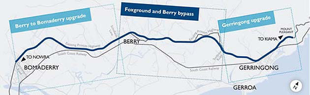
In March 2006 Roads and Maritime Services announced, through a series of community workshops and information days, a project to upgrade the Princes Highway between Gerringong and Bomaderry to a four lane highway with median separation.
In November 2007 Roads and Maritime displayed the route options and in June 2009 announced a preferred option for the upgrade of the Princes Highway between Gerringong and Bomaderry. Roads and Maritime is now constructing the works as three separate projects:
- Gerringong upgrade – Mount Pleasant to Toolijooa Road (construction complete August 2015)
- Foxground and Berry bypass – Toolijooa Road to just south of Andersons Lane (under construction)
- Berry to Bomaderry upgrade – Mullers Lane to Cambewarra Road (in planning).
Since June 2009 Roads and Maritime has undertaken extensive community consultation to develop the concept design and environmental assessment for the Foxground and Berry bypass project.
Key features
Some key features of the concept design include:
- Around 6.6 kilometres of new highway, including bypasses of the Foxground bends and the Berry township
- Interchanges at Toolijooa Road, Austral Park Road, Tindalls Lane and the northern and southern interchanges for Berry
- Junction arrangements at Schofields Lane and Gembrook Lane which enable both northbound and southbound access to the highway
- A cutting about 25 metres deep at Toolijooa Ridge, bypassing the Foxground bends
- Six lanes through the cutting at Toolijooa Ridge for a distance of 1.5 kilometres, providing two lanes and a climbing lane in each direction
- Three bridge crossings at Broughton Creek and a bridge at Berry
- An upgrade and extension of Austral Park Road
- A new roundabout at the junction of Woodhill Mountain Road and the existing Princes Highway
- A diversion of Town Creek into Bundewallah Creek
- Proposed local road closure at North Street
- Victoria Street to remain open with a two-way connection between Queen and Victoria streets and a southbound on-ramp south of Victoria Street
- New property accesses and access roads. Left-in / left-out only for direct property access to the upgraded highway
- Wildlife crossings (rope bridges and underpasses) to maintain existing wildlife corridors.
Benefits
Benefits of the upgrade would include:
- Improving road safety on the Princes Highway and local road network
- Reducing total crashes on the Princes Highway in the project area by an estimated 64 per cent
- Improving road safety through less interaction between traffic and pedestrians in the town of Berry
- Improving the efficiency of the Princes Highway between Toolijooa Road and just south of Andersons Lane
- Reducing travel time by an estimated seven minutes
- Supporting regional and local economic development
- Generating local employment opportunities
- Providing value for money
- Improving flood immunity
- Improving wildlife crossings.
Route options development
From May 2006 to November 2007 Roads and Maritime held a number of community workshops and information sessions to advise the community on the route selection process, comprising the identification of route options and preferred option selection.
Six objectives were set for the project:
- Improve road safety (on the Princes Highway and adjacent road network).
- Improve the efficiency of the Princes Highway between Gerringong and Bomaderry.
- Support regional and local economic development.
- Provide value for money.
- Enhance potential beneficial environmental effects and manage potential adverse environmental impacts.
- Optimise the benefits and minimise adverse impacts on the local social environment.
In November 2007 Roads and Maritime displayed seven route options for the Gerringong to Bomaderry Princes Highway upgrade. The route options were placed on public display for a period of three months with members of the community invited to attend staffed displays, information sessions and workshops.
To review project documentation for the planning process and route options development please refer to the Gerringong to Bomaderry document library page.
Preferred option
In October 2008 Roads and Maritime announced the preferred option for the upgrade of the Princes Highway between Gerringong and Bomaderry following extensive investigation and assessment of the feasible options.
Roads and Maritime needed to determine how the road would be designed and constructed. In the interests of determining viable and effective options, a number of factors needed to be assessed. Roads and Maritime undertook geotechnical investigations of the land where the structure was likely to be located, environmental assessments of the area to identify items of significance and conducted an analysis of current road safety and operational issues in the area. Roads and Maritime also publicly displayed the access options for the townships of Berry and Gerringong.
In June 2009, Roads and Maritime finalised the preferred option and announced the preferred access options for Berry and Gerringong.
Since 2009 Roads and Maritime has worked with project stakeholders to amend and improve the concept design, including:
- Amendments to Berry access arrangements to aim for southbound flood free access.
- Modifications to the northern Berry bypass alignment and the bridge at Berry.
- Amendments to the Kangaroo Valley Road interchange to avoid linking into Huntingdale Park Road.
To review project documentation for the preferred option phase of the project please refer to the Gerringong to Bomaderry document library page.
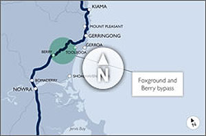
Project locality map
View the Foxground and Berry bypass project locality map (GIF, 54KB).
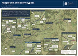
Approved concept design map
View or download the approved concept design map.