Swansea Channel dredging
Project overview
Transport for NSW is part of multi-agency joint initiative that will provide reliable, safe and navigable access to Lake Macquarie.
Latest news
July 2025 – Stage 3 maintenance dredging work finishing soon
Our current maintenance dredging campaign is on track to finish. With on-water work wrapping up next week and site pack-down by month’s end.
We're also advancing our 10-year REF for the new Dredge and Sand Transfer System. We will be inviting your feedback on this soon.
For more information on the new Dredge and Sand Transfer System you can visit the Lake Macquarie City Council website.
May 2025 - Stage 3 maintenance dredging
Dredging in the Swansea Channel will begin in the coming weeks (subject to weather conditions) with the NSW Government continuing its commitment to maintaining safe and accessible waterways in the Swansea Channel.
Dredging activities will concentrate on the Dog Leg section of the channel (see map), with an estimated 10,000 cubic metres of material to be removed during Stage 3. The scope of our work will include:
- establishing a temporary work site at the following locations: Elizabeth Island, Rathmines Boat Ramp, Naru Point and on water
- installing environmental controls and a work area on Elizabeth Island to pump dredge sand to this location
- the dredging operation itself
- demobilising equipment and restoring the temporary work areas when dredging is finished.
For safety reasons, please stay away from the dredging work area shown on the map. Our dredging vessel is using underwater pipes to move sand to Elizabeth Island. Since the vessel moves daily, the submerged pipes also shift. These pipes may not always be visible, so we urge all vessel operators in the area to be extra cautious or use the alternative Airforce Channel during our work.
For more information on this work read our latest community update (PDF, 672.37 KB).
November 2024 - New dredging and sand transfer project
Lake Macquarie will be benefit from an additional $16 million investment in dredging infrastructure through a joint initiative by the Federal, State and Local Government.
Lake Macquarie Council has now been awarded $10 million Federal funding which will be used to design and construct a dredge and sand transfer system.
Transport for NSW has also secured $6 million in funding from the State Government to assist with providing five years of operation for the dredge and sand transfer system which we will manage on behalf of Council.
This first of its kind joint dredging project between Federal, State and Local governments will address the long standing challenges that has faced Lake Macquarie with continual need to remove sand accumulation in Swansea Channel.
View the latest community update for more information (PDF, 1.75 MB)
August 2024 - Stage Two dredging complete
Stage Two of the Swansea Dredging program is now complete. A total of 13,000 cubic metres of sand was removed from the Dog Leg (approximately 10,000 cubic metres) and the channel northwest of the Swan Bay entrance (approximately 3,000 cubic metres).
We expect the hydrographic survey to be available shortly and will post it on this page as soon as it’s ready.
We will continue to monitor the channel depths and dredge again next year with another campaign if required.
May 2024 - Stage Two dredging
Stage Two of the Swansea Dredging program is currently underway. Transport for NSW will dredge up to a further 13,000 cubic metres from various points in the channel, and sand deposited on Elizabeth Island (see map below).
We anticipate this stage of the dredging will be completed mid-2024, subject to environmental conditions.
Safe navigation through any channel is the responsibility of the vessel master, considering a range of factors including the size and draft of their vessel, weather, tides, water depths and the speed at which they travel.
Conditions and depths can change regularly so caution should be used when navigating the area. Skippers of deep-drafted vessels are advised to carefully plan any trips in this area, navigate with caution and if in doubt, avoid the trip entirely.
Image
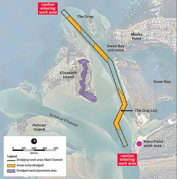
Image controls:
January 2024 – Dredging complete
Lake Macquarie boaters can now enjoy better access to Lake Macquarie, as Transport for NSW completes stage one of dredging in the Swansea Channel. 16,690 cubic metres of sand were removed from three areas to create a 30-metre-wide channel, extending from the Dog Leg southeast of Elizabeth Island, up to the Drop Over northwest of the Swan Bay Entrance.
This work completes the first phase of this two-stage dredging campaign to create a safe, navigable channel for boats, with more dredging scheduled to begin mid-2024. Boaters can find more information about the channel depth by viewing the post-dredge hydrographic survey, available here.
As part of the dredging project, Transport for NSW has been working with experts to create a desirable breeding area for the endangered birds by placing dredged sand on Elizabeth Island. Lake Macquarie is now awash with adorable Little Tern chicks, with our experts counting eight nests and at least ten chicks in the area.
December 2023 - Community update
Transport for NSW continues dredging the Swansea Channel and we expect the work completed to date will greatly improve access for many boaters.
Due to adverse weather conditions and mechanical issues with the dredge, we will need to return to finalise dredging in January.
Dredging of the Dog Leg area is complete, with the results of our hydrographic survey now available (see the survey under Project Documents below). The work on the Dog Leg involved the majority of sand movement and improves navigation through the channel.
We have completed some dredging at the Drop Over, before moving to the Swan Bay entrance for better protection from incoming adverse weather. We will continue working in that area until 24 December.
From 24 December, the dredge will demobilise so the public can enjoy using the channel during the holidays.
Navigational markers have been put in place this week, and to assist boaters in determining if the area is safe and navigable for their vessel. All work for this year is now complete and the very latest results are shown in the Hydrographic surveys in the Navigation In formation section below.
We would like to remind boaters that conditions and depths can change regularly so caution should be used when navigating in the area.
Our contractor will be back on site to remobilise the dredge and resume works in January.
We apologise for any inconvenience and thank the community for their ongoing patience.
Please read the December 2023 community update and see the latest Hydrographic Survey (PDF, 2.58 MB) (which shows current water depths) under Project Documents on this page.
November 2023 - Dredging progress update
The current dredging campaign in the Swansea Channel involves three areas:
- the Dog Leg
- the Swan Bay Entrance
- the Drop Over
As per our last update, we indicated that the first section of work in the Dog Leg area would be completed by the end of November.
Movement of sand within the Dog-Leg section is complete, with a post-dredge hydrographic survey scheduled for next week to ensure the desired depth and width has been achieved.
The work on the Dog Leg involved the vast majority of sand movement and improves movement through the channel. However, we understand that some vessels with larger drafts may still be impacted until the other two sections are also complete.
Upon completion of hydrographic survey at the Dog Leg section, the dredge will move to the Swan Bay Entrance and the Drop Over to remove the remainder of sand, which is about 3,000 cubic metres.
The campaign of all three areas is expected to be completed by mid-December, weather permitting.
The dredge will still be operating in the channel until this time, and we ask vessels to be aware of dredging work taking place, including sand pipes within the water.
We will share the hydrographic surveys once they are completed, which may provide some additional information for boaters.
Image
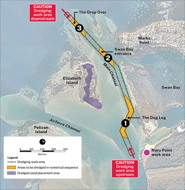
Image controls:
Project information
Background
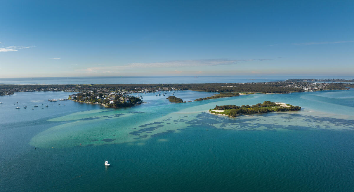
Swansea Channel connects Lake Macquarie to the Pacific Ocean and Is the only entrance to the popular boating area in the Hunter region. Lake Macquarie is twice the size of Sydney Harbour and the largest saltwater lake in the Southern Hemisphere.
The history of Swansea Channel indicates that this is not a natural continually open navigational channel into Lake Macquarie. Since 1970 Swansea Channel has been dredged 24 times.
Interventions such as the construction of the Lake Macquarie Entrance Breakwaters in the late 1800s were built to allow larger vessels in for industry purposes.
Due to the dynamic nature of Swansea Channel there will be continual need for interventions such as dredging to maintain the channel.
While there is good access to the lake for the majority of users with boats on trailers that can launch from one of the many boat ramps around the shoreline, maintaining access to the ocean through the narrow Swansea Channel is of major importance to recreational boating in the region, particularly cruising yacht clubs.
What are we doing?
Maintenance dredging
Transport for NSW has completed three maintenance dredging campaigns since 2023. Over these three years 70,000 cubic metres of sand was removed from Swansea Channel improving navigation and access to Lake Macquarie.
We will continue to monitor the channel and maintenance dredging will take place as needed.
Obtaining 10-year environmental approval
We are preparing a Review of Environmental Factors that can be used for the dredging operations for the next 10 years.
We will seek your comments and feedback on the proposed dredging project, methods and sand placement in 2025.
Dredge and sand transfer project
Lake Macquarie Council has been awarded $10 million in federal grant funding to design and construct a permanent dredge and sand transfer system. This would allow for more frequent and reliable dredging of Swansea Channel and improve navigation and access to Lake Macquarie.
Transport for NSW has secured $6 million from the State Government to fund operational costs of the dredge and sand transfer system for the next five years which we will manage on behalf of Council.
This first of its kind joint initiative between federal, state, and local governments will address long-standing challenges the sand-build up has caused in the channel.
We are part of the joint team delivering the dredge and sand transfer project. Our staff have been embedded with the Council team who are delivering the dredge and sand transfer infrastructure.
For more information, please visit the Lake Macquarie City Council website.
Next steps
- 2025 - Council has awarded the contract for the dredge and sand transfer system infrastructure
- 2025 - complete the Stage 3 maintenance dredging campaign
- 2025 - TfNSW will seek community feedback on the 10-year environmental approval
- 2025 - TfNSW will obtain the 10-year environmental approval and publish the submission report
- 2026 - Council will manage the construction of dredging Infrastructure
- 2027 to 2031 - TfNSW will operate and manage the dredging infrastructure.
Community information
Community updates
Project documents
Some documents on this page may not comply with accessibility requirements (WCAG). If you are having trouble accessing information in these documents, please contact us.
Environmental Approval
- June 2023 minor works review of environmental factors (PDF, 24.83 MB)
Swansea Channel dredging.
Water depth information
- 17 January 2024 Hydrographic Survey (PDF, 2.58 MB)
- 22 December 2023 Hydrographic Survey (PDF, 3.58 MB)
- 22 December 2023 Hydrographic Survey-Dog Leg (PDF, 6.02 MB)
- 22 December 2023 Hydrographic Survey-Area 2 (PDF, 1.57 MB)
- 22 December 2023 Hydrographic Survey-Area 3 (PDF, 1.48 MB)
- December 2023 Hydrographic Survey (PDF, 2.12 MB)
- December 2022 Swansea Channel Alternative Navigation Route Map (PDF, 214.53 KB)
- March 2022 Swansea Channel Hydrographic Survey (PDF, 15.64 MB)
- October 2021 Swansea Channel Hydrographic Survey (PDF, 17.67 MB)
Contact us
For more information contact the project team:
Phone: 1800 271 100