Sydney Clearways Program - Easing Sydney's Congestion Program Office
Project overview
The NSW Government is acting to reduce congestion and delays on Sydney’s roads by installing new and extended clearways.
Nominate a clearway
If there is a road that you travel along, that is congested and you think would be improved with changes to the existing clearway or the addition of a new clearway, email us with the details.
Your nomination, together with traffic data, will help us improve the reliability of roads in Sydney.
Program information
Background
In December 2013, the NSW Government published the Sydney Clearways Strategy which identified routes on Sydney’s road network that could benefit from new clearways.
Read or download the Sydney Clearways Strategy for more information.
Clearways announcements
No announcement at this moment.
Clearways engagement
- Hume Highway - Villawood to Strathfield South
- Pittwater Road, Collaroy
- Eastern Valley Way and Clive Street - Babbage Road, Roseville Chase to Sailors Bay Road, Northbridge
- Barrenjoey Road, Pittwater Road and Manly Road - Mona Vale to the Spit
- Condamine Street, Burnt Bridge Creek Deviation and Manly Road - Brookvale to The Spit
What's next?
We are continuing to investigate roads as identified in the Sydney Clearways Strategy that would benefit from new and extended clearways.
What is a clearway?
A clearway is a section of road where stopping or parking is prohibited. Buses and taxis are permitted to stop when dropping off or picking up passengers.
Preliminary investigations show that clearways can help manage congestion in many areas of Sydney by allowing motorists to use all traffic lanes.
For consistency across the road network and to make it easier for road users, clearway hours are standard across the network. Wherever possible, we use the following standard hours:
- weekday morning (6am - 10am)
- middle of weekday (10am - 3pm)
- weekday afternoon (3pm - 7pm)
- weekend short day (9am - 6pm)
- weekend long day (8am - 8pm)
- 24 hours across seven days (At All Times)
$21 million was committed to the implementation of the Sydney Clearways Strategy as part of the $246 million Pinch Point Program.
In November 2014, the NSW Government committed a further $100 million to the implementation of the strategy bringing the total value of the clearways program to $121 million.
How do clearways reduce congestion?
Clearways help reduce congestion on many Sydney roads where the road is close to capacity and parking disrupts the flow of traffic
When vehicles are parked in the kerbside lane, fewer lanes are available to traffic and road users are also forced to merge from the kerbside lane which can create significant delays and queues.
By removing the parking, an additional lane is available for road users which helps traffic flow and manage congestion.
Clearways also allow us to tow vehicles that are stopped illegally or broken down.
This ensures all lanes are available to traffic when they are needed most.
More information
For further information about Sydney's Clearways Strategy, see the fact sheet.
For frequently asked questions about new and extended clearways, see the FAQ.
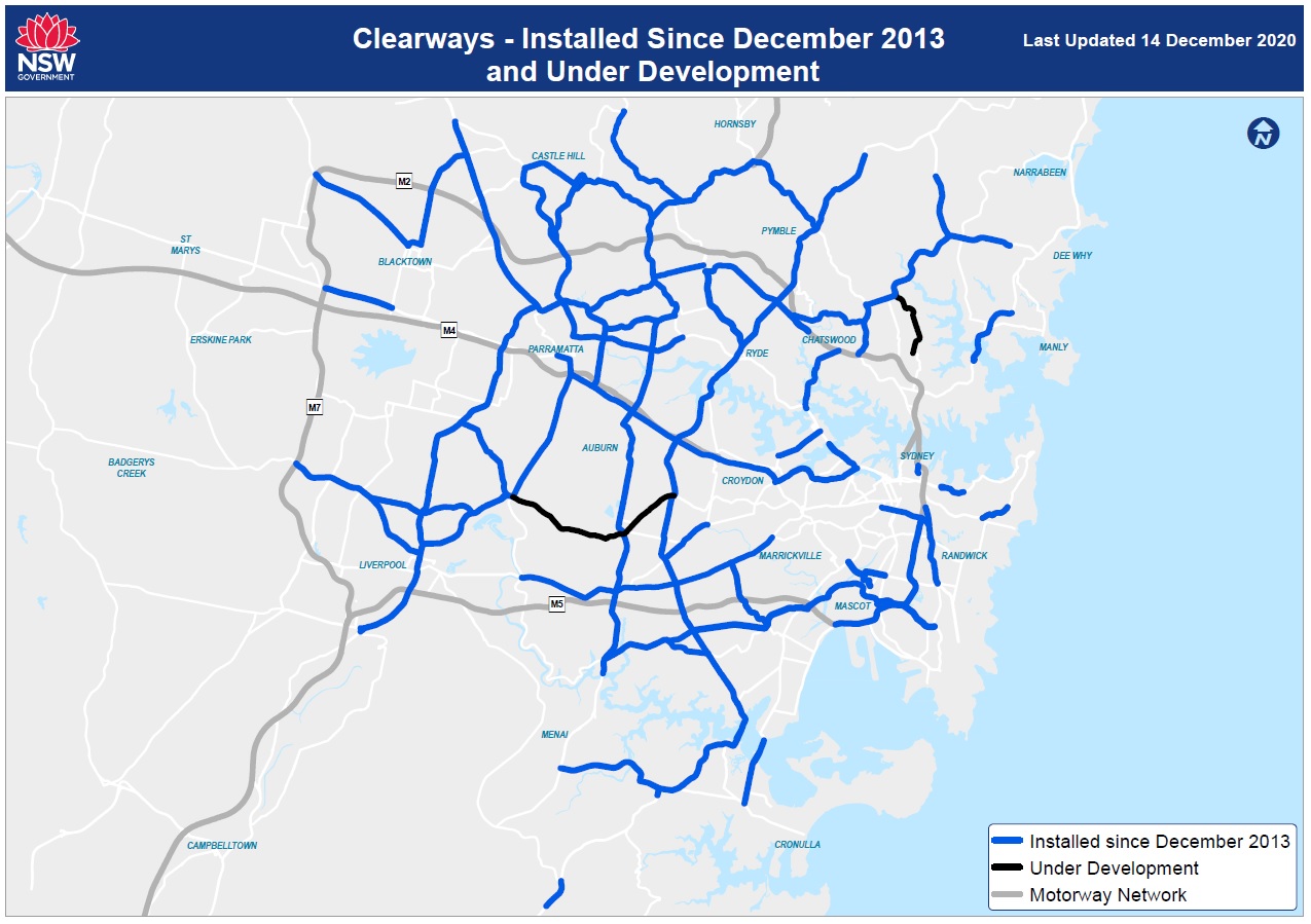
Installed clearways
2020 - 2021
In the 2020-21 financial year we have installed 7 kilometres of clearways, bringing the total new and extended clearways installed since December 2013 to approximately 743 kilometres.
2019 - 2020
In the 2019-20 financial year we have already installed close to 157.8 kilometres of clearways, bringing the total new and extended clearways installed since December 2013 to approximately 736 kilometres.
- Mascot & Alexandria - Canal Road, Ricketty Street & Gardeners Road Kent Road, Coward Street & Bourke Road
- Blaxland Road between Devlin Street, Ryde and Epping Road, Epping
- Stoney Creek Road and Forest Road – King Georges Road, Beverly Hills to the M5 East Motorway, Arncliffe
- Milperra Road and Canterbury Road – Henry Lawson Drive, Milperra to New Canterbury Road, Hurlstone Park
- Boundary Road and New Line Road - Pennant Hills Road, Pennant Hills to Old Northern Road, Dural
- King Georges Road – M5 Motorway, Beverly Hills to Stoney Creek Road, Beverly Hills
- Woodville Road - Parramatta Road, Granville to Hume Highway, Villawood
- Cabramatta Road West - Elizabeth Drive, Bonnyrigg to Cumberland Highway, Cabramatta
- Delhi Road, Millwood Ave, Fullers Road and Pacific Highway - North Ryde to Roseville
- Richmond Road – the M7 Motorway, Dean Park to Third Avenue, Blacktown
- Spit Road, Manly Road and Burnt Bridge Creek Deviation – Medusa Road, Mosman to Condamine Street, Balgowlah
- Airport Drive, Qantas Drive, Joyce Drive and General Holmes – Marsh Street, Arncliffe to Mill Pond Drive, Mascot
- Old South Head Road - Syd Einfeld Drive, Bondi Junction to Curlewis Street, Bondi
- Bexley Road – Canterbury Road, Campsie to Forest Road, Bexley
- Kissing Point Road – James Ruse Drive, North Parramatta to Stewart Street, Dundas Valley
2018 - 2019
In the 2018-19 financial year we have already installed 157.6 kilometres of clearways, bringing the total new and extended clearways installed since December 2013 to approximately 578.5 kilometres.
- Old Northern Road - Showground Road, Castle Hill to Windsor Road, Baulkham Hills
- Third Avenue and Sunnyholt Road – Richmond Road, Blacktown to Old Windsor Road, Stanhope Gardens
- South Dowling Street, Southern Cross Drive and General Holmes Drive - Cleveland Street, Moore Park to M5 East Motorway, Mascot
- Hume Highway - Cumberland Highway, Liverpool to Henry Lawson Drive, Villawood
- Cabramatta Road - Cumberland Highway, Cabramatta to Hume Highway, Cabramatta
- Castle Hill Road - Old Northern Road, Castle Hill to Pennant Hills Road, West Pennant Hills
- Castle Hill Town Centre - Cecil Avenue, Terminus Street, Old Northern Road, Pennant Street and McMullen Avenue
- New South Head Road - Waratah Street/McLachlan Avenue, Rushcutters Bay to Bay Street, Double Bay
- The Horsley Drive - Cumberland Highway, Smithfield to and Hume Highway, Carramar
- Henry Lawson Drive, Forest Road and Stoney Creek Road - Davies Road, Padstow Heights to King Georges Road, Penshurst
- Lyons Road - Great Northern Road, Five Dock to Victoria Road, Drummoyne
- Taren Point Road - Captain Cook Bridge, Taren Point to The Kingsway, Caringbah
- Windsor Road - Showground Road, Castle Hill to Seven Hills Road, Baulkham Hills
- Great Western Highway - M7 Motorway, Blacktown to Reservoir Road, Blacktown
- Pacific Highway - Pennant Hills Road, Wahroonga to Mona Vale Road, Pymble
- Elizabeth Drive - My Motorway, Cecil Hills to Hume Highway, Liverpool
2017 - 2018
In the 2017-18 financial year we installed 226.2 kilometres of clearways, bringing the total new and extended clearways installed since December 2013 to 420.9 kilometres.
- King Georges Road - Stoney Creek Road, Penshurst to Princes Highway, Blakehurst
- Old Windsor Road – Windsor Road, Kellyville Ridge to M7 Motorway, Glenwood
- Forest Way - Wyatt Avenue/Morgan Road, Belrose to Warringah Road, Frenchs Forest
- Warringah Road - Roseville Bridge, Roseville Chase to Beacon Hill Road, Beacon Hill
- Showground Road - Windsor Road, Castle Hill to Old Northern Road, Castle Hill
- Roberts Road and King Georges Road - Hume Highway, Greenacre to M5 Motorway, Beverly Hills
- Old Windsor Road - M7 Motorway, Glenwood to Hart Drive, Constitution Hill
- Centennial Avenue and Burns Bay Road - Epping Road, Lane Cove to Victoria Road, Huntleys Point
- Pacific Highway - Fullers Road, Chatswood to Gore Hill Freeway, Artarmon
- Windsor Road and Church Street - Old Northern Road, Baulkham Hills to Victoria Road, Parramatta
- Victoria Road - Church Street, Parramatta to Marsden Road, Ermington
- Cleveland Street - City Road, Camperdown to Anzac Parade, Moore Park
- Carlingford Road - Pennant Hills Road, Carlingford to Beecroft Road, Epping
- Boundary Street and Babbage Road -Pacific Highway, Roseville to Roseville Bridge, Roseville Chase
- Punchbowl Road - King Georges Road, Punchbowl to Coronation Parade, Croydon Park
- Pennant Hills Road - James Ruse Drive, Oatlands to Pacific Highway, Wahroonga
- James Ruse Drive, Briens Road and Old Windsor Road - Parramatta Road, Clyde to Hart Drive, Constitution Hill
- Marsden Road – Stewart Street, Dundas Valley to Pennant Hills Road, Carlingford
- Old Princes Highway, The Grand Parade, Linden Street, The River Road and Bangor Bypass - Acacia Road, Kirrawee to New Illawarra Road, Menai
- Epping Road - Beecroft Road, Epping to Mowbray Road West, Lane Cove
- Stacey Street, Fairford Road, Davies Road and Alfords Point Road - Hume Highway, Bankstown to Alfords Point Bridge, Padstow Heights
2016 - 2017
In the 2016-17 financial year we installed 87 kilometres of clearways, bringing the total new and extended clearways installed since December 2013 to 194.7 kilometres.
- City West Link, Dobroyd Parade and Wattle Street - Victoria Road, Rozelle to Parramatta Road, Ashfield
- Cumberland Highway - Old Windsor Road, Constitution Hill to Hume Highway, Liverpool
- Mona Vale Road - Pacific Highway, Pymble to Kitchener Street, St Ives
- Princes Highway (northbound) - Jennings Road, Heathcote to Heatcote Road, Heathcote
- Silverwater Road and Stewart Street - Parramatta Road, Auburn to Marsden Road, Ermington
- St Hilliers Road, Boorea Street, Olympic Drive, Joseph Street, Rookwood Road and Stacey Street - Parramatta Road, Auburn to Hume Highway, Bankstown
2015 - 2016
In the 2015-16 financial year we installed 91.2 kilometres of clearways, bringing the total new and extended clearways installed since December 2013 to 107.7 kilometres.
- Concord Road, Homebush Bay Drive and Centenary Drive - Rhodes to Strathfield
- Church Street/Devlin Street/Lane Cove Road - Ryde Bridge, Ryde to Bridge Road, North Ryde
- Great Western Highway, Church Street and Parramatta Road - Pitt Stree, Parramatta to M4 Motorway, Strathfield
- Lane Cove Road - Bridge Road, North Ryde to Fontenoy Road, Macquarie Park
- Princes Highway - King Georges Road, Blakehurst to President Avenue, Kirrawee
2014 - 2015
In the 2014-15 financial year we installed 12.5 kilometres of clearways, bringing the total new and extended clearways installed since December 2013 to 16.5 kilometres.
Feedback
We’ve heard that clearways keep you moving – look what some of our road users have to say about recently installed clearways!
- 'Thank you. Thank you. For finally making New South Head Road through Edgecliff a clearway.' - Daniel, Edgecliff.
- 'Wow! That’s fantastic! Well done to the people who made this happen.” – Kim, Taren Point resident.
- “This [clearway] is a wonderful initiative. Long overdue. It will not only greatly improve traffic flow but also safety. Well done to all responsible.” – John, Edgecliff.
- “I’m a great fan of clearways. I think roads should be used to move people and goods not to help park cars.” – Robert, Rosebay.
- “Excellent. That’s common sense really.” – David, Taren Point.
Project documents
Some documents on this page may not comply with accessibility requirements (WCAG).
If you are having trouble accessing information in these documents, please contact us.
Media releases
- 23 March 2020
Traffic flow to improve along Blaxland Road.
- 13 September 2019
New rail bridge placed over Castlereagh Road.
- 6 December 2019
New clearways on the way for New Line Road and Boundary Road.
Contact us
If your vehicle has been towed from a clearway, please call the Transport Management Centre on 131 700
For further information about this project, please contact:
Phone: 1300 706 232
Email:clearways@transport.nsw.gov.au