Pacific Highway between Turramurra and Wahroonga
Project overview
The NSW Government has committed over $825 million to pinch point projects which would ease congestion, reduce traffic delays and improve travel times on Sydney’s major roads.
The NSW Government funded the completed improvements at intersections on the Pacific Highway at Fox Valley Road, Redleaf Avenue and Coonanbarra Road, to ease congestion and improve traffic flow. The Australian Government and NSW Government have jointly funded the upgrades at the Pacific Highway and Finlay Road. The project was completed in late 2022.
Latest news
Dec 2022 - Project update
Improvements at the intersections on Pacific Highway at Fox Valley Road, Redleaf Avenue and Coonanbarra Road are completed and is now open to traffic from 29 November 2022.
View the open to traffic community notification for more information.
The map is also available to view or download here (PDF, 3.7Mb).
Nov 2022 - Permanent change to traffic conditions
New signalised intersection at Redleaf Avenue and ‘No Right Turn’ at Coonanbarra Road from Monday 21 November'. View the signalised intersection community notification (PDF, 332Kb) for more information.
Project information
Background
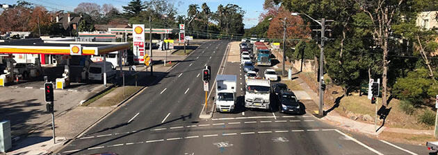
Around 60,000 vehicles a day travel on Pacific Highway between Turramurra and Wahroonga. The intersections of the Pacific Highway with Redleaf Avenue and Coonanbarra Road, Fox Valley Road and Finlay Road have been identified as pinch points, or bottlenecks, on this busy corridor. These intersections service surrounding residential, commercial and industrial areas, are part of the major arterial road to Sydney’s central business district from the north western suburbs and are key to accessing the Central Coast via the M1 Pacific Motorway.
We will upgrade these intersections, widening the Pacific Highway to provide three continuous northbound lanes and adjusting the turning movements to and from the cross streets. This will provide northbound motorists savings on travel time particularly in the afternoon peak, better traffic flow through the intersections and provide safer road conditions along the Pacific Highway.
We have engaged with the community in September-October 2018 on the project and after considering all responses, along with the project’s objectives, we have decided to:
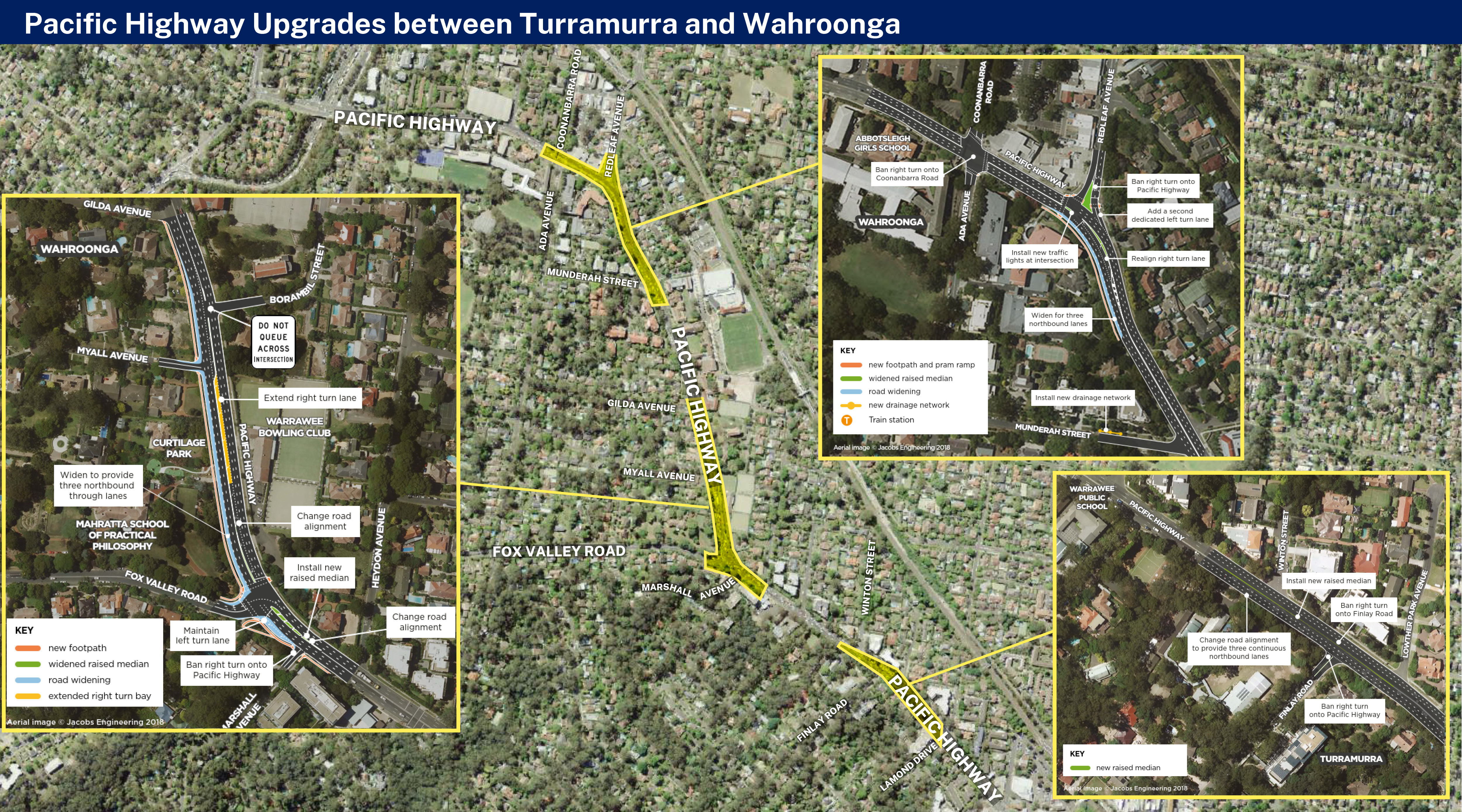
Pacific Highway at Redleaf Avenue and Coonanbarra Road
At this intersection we will:
- widen the western side of Pacific Highway to provide three continuous northbound lanes
- install traffic lights at the intersection at Redleaf Avenue, including adding pedestrian crossings on the northern and western sides of the intersection
- ban the right turn from Pacific Highway northbound onto Coonanbarra Road and convert the existing right turn lane into a northbound through lane
- change the alignment of the existing right turn lane from Pacific Highway northbound onto Redleaf Avenue
- ban right turns from Redleaf Avenue onto Pacific Highway northbound
- create an additional left turn lane from Redleaf Avenue onto Pacific Highway southbound.
View the Pacific Hwy at Coonanbarra Rd and Redleaf Av intersection map (PDF, 15.7Mb) showing the upgrades.
Pacific Highway at Fox Valley Road
At this intersection we will:
- widen the western side of Pacific Highway to provide three continuous northbound lanes
- provide a dedicated left turn lane from Pacific Highway northbound onto Fox Valley Road
- extend the dedicated right turn lane from Pacific Highway southbound onto Fox Valley Road
- widen the raised median on Pacific Highway northbound, north and south of Fox Valley Road
- ban the right turn from Marshall Avenue onto Pacific Highway southbound.
View the Pacific Hwy at Fox Valley Rd intersection map (PDF, 479Kb) showing the upgrades
Pacific Highway at Finlay Road
This intersection upgrade is part of a $240 million investment by the Australian and NSW Governments to fast‑track 11 congestion-busting projects as part of the plan to stimulate the economy as it recovers from the COVID‑19.
At this intersection we will:
- provide three continuous northbound lanes
- ban the right turn from Pacific Highway southbound onto Finlay Road
- ban the right turn from Finlay Road onto Pacific Highway southbound.
View the Pacific Hwy at Finlay Rd intersection map (PDF, 421Kb) showing the upgrades
Benefits
The upgrade benefits include:
- northbound travel time savings
- improved traffic flow and efficiency at the intersections
- reduced queue lengths and delays at the intersections
- improved road safety along the corridor through removal of right turn movements at Finlay Road, Marshall Avenue and Coonanbarra Road
- improved pedestrian and road user safety at the intersection of the Pacific Highway and Redleaf Avenue by installing traffic lights and adding signalised pedestrian crossings on the northern and western side of the intersection
- improved road safety at the intersections of the Pacific Highway and Fox Valley Road, Redleaf Avenue and Coonanbarra Road by realigning the curve of the road and traffic lanes.
What happens next?
During July – September 2021, we will work on the Pacific Highway at Redleaf Avenue and Fox Valley Road to continue private property adjustments work, utilities relocation, traffic signal works and road pavement work such as concreting and asphalting.
We will inform the community as the project progresses.
If you have any comments about the project, you can contact our delivery partner, Ward Civil on 1800 897 841 or projects@wardcivil.com.au.
Community information
Frequently asked questions (FAQs)
- What is the Pinch Point Program?
The Pinch Point Program provides low cost, high benefit proposals to improve congestion on Sydney’s roads today. - What is a pinch point?
A pinch point is a traffic congestion point, either at an intersection or on a short length of road, where a traffic bottleneck exists. They cause traffic build-up and travel delays at these spots and on the wider road network. - Why does Pacific Highway between Turramurra and Wahroonga need upgrading?
Currently, northbound motorists are experiencing heavy congestion, poor travel times and long delays when travelling between Turramurra and Wahroonga, particularly during the afternoon peak period. This situation is worsened by the Pacific Highway northbound lanes dropping from three lanes to two lanes along this section of the corridor.
Roads and Maritime propose to provide more efficient, safer and reliable travel times by widening the road to provide three continuous lanes in the northbound direction whilst maintaining the three existing southbound continuous lanes along this section of the corridor.
Road widening, and other improvements, would provide significant benefits, particularly in the afternoon peak for motorists travelling northbound along the Pacific Highway.
- What are the key benefits of proposed Pacific Highway upgrades?
Key benefits include:
- northbound travel time savings
- improved traffic flow and efficiency at the intersections
- reduced queue lengths and delays at the intersections
- improved road safety along the corridor through removal of right turn movements at Finlay Road, Marshall Avenue and Coonanbarra Road
- improved pedestrian and road user safety at the intersection of the Pacific Highway and Redleaf Avenue by removing the southbound left turn slip lane and providing a pedestrian refuge on Redleaf Avenue
- improved road safety at the intersections of the Pacific Highway at Fox Valley Road, and at Coonanbarra Road and Redleaf Avenue, by realigning the curve of the road and traffic lanes.
More information: - Pacific Highway upgrade project locations overview map (PDF, 2.1Mb)
- Pacific Highway and Finlay Road map (PDF, 427Kb)
- Pacific Highway and Fox Valley Road map (PDF, 504Kb)
- Pacific Highway at Coonanbarra Road and Redleaf Avenue map (PDF, 499Kb)
- Is the local council aware of the project?
Roads and Maritime is strongly committed to working closely with Ku-ring-gai Council and other stakeholders during all stages of the project. Working with Ku-ring-gai Council ensures we achieve the best outcomes for the Pacific Highway corridor work and the community. We have consulted with Ku-ring-gai Council during planning and will continue to work with Council as the project progresses. - Would there be any property impacts?
Road widening would require strip adjustments to some properties on the northbound side of the Pacific Highway, between Turramurra and Wahroonga. Roads and Maritime are in contact with all potentially impacted property owners. We will continue to work with potentially impacted property owners as the project progresses. - What about heritage listed properties?
The road widening works would impact some local and State heritage listed properties along the northbound side of the Pacific Highway.
Roads and Maritime is strongly committed to working closely with Ku-ring-gai Council and the Office of Environment and Heritage (OEH) to reduce the potential impacts on any local or State heritage listed properties that could be impacted by this project. We will work with Ku-ring-gai Council and the OEH during all stages of the project.
- What vegetation would be impacted if the project goes ahead?
Road widening works would primarily impact roadside vegetation and trees on the northbound side of the Pacific Highway. The impacted vegetation and trees would be on public land (within the existing road corridor and council owned land) and private properties where strip adjustments would be required.
Roads and Maritime has developed the proposed design to minimise the loss of vegetation and trees where possible. A Review of Environmental Factors (REF) is being prepared to assess the potential environmental impacts of the proposal (including the removal of roadside vegetation and trees) and outline measures to manage and mitigate these impacts, should the project proceed.
To offset the removal of vegetation and trees, landscape planting plans would be prepared in consultation with the impacted property owners and implemented following construction. Further investigations will be done in the project design phase to determine the extent of landscaping works required to replace any vegetation or trees that would be removed as a result of the potential road upgrades. This work will be done in consultation with impacted property owners, utility providers, relevant state government agencies and Ku-ring-gai Council.
Indicative mitigation planting has been included on visualisations (PDF, 8.6Mb) to show suggested replanting options along the potentially impacted areas of the road corridor following construction.
- Would all proposed upgrade works proceed to construction?
The project is currently in design phase. Although we may not have the capacity to fund all proposed Pacific Highway upgrades, our decision will be informed by community and stakeholder feedback.
To further inform potential corridor upgrade planning and development, we will also carry out additional investigation work at the intersections of the Pacific Highway and Fox Valley Road and the Pacific Highway and Coonanbarra Road between September and November 2018.
We will decide how to proceed with potential works once all relevant information has been collated.
The community is advised prior to work commencing on any Roads and Maritime project.
- When would upgrade work commence?
The project is currently in design phase. Community consultation feedback will inform progression of the project, along with project design requirements. We will decide how to proceed with potential work once all relevant information has been collated.
It is anticipated that any construction work would commence early 2020, and be completed by June 2021.
Further communication will be provided to the community and stakeholders as the project progresses.
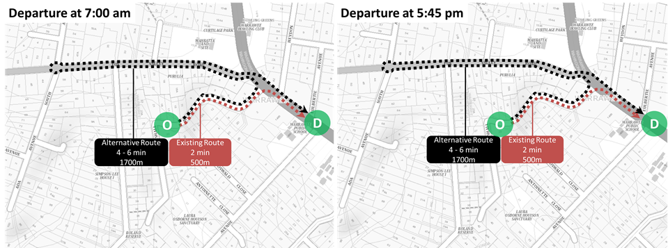
- What would be the alternate routes for Finlay Road motorists?
Finlay Road primarily services the surrounding residential area and Warrawee Public School community. Widening the Pacific Highway to provide three continuous northbound lanes at the intersection of the Pacific Highway and Finlay Road would require vehicles turning right into, or out of, Finlay Road to cross three lanes of northbound traffic compared to the current situation with two lanes.
The crash history data for the Finlay Road intersection in the five-year period between 1 January 2011 and 31 December 2016 shows that there were five reported crashes at the intersection. The introduction of the right turn bans are expected to reduce crash rates at this intersection, particularly for vehicles turning right out of Finlay Road onto the Pacific Highway.
Based on traffic counts collected in March 2017, the number of vehicles turning right out of Finlay Road was insignificant (one vehicle per hour in both the AM and PM peaks). In general, these vehicles can currently find a suitable gap to turn within half a minute in both peaks. As a result of traffic growth on the Pacific Highway, delays could potentially increase to two minutes in both peaks in 2027.
Based on the traffic counts collected in March 2017, the highest number of vehicles turning right into Finlay Road was 60 vehicles per hour, during the AM peak. In general, these vehicles can currently find a suitable gap to turn within half a minute in both peaks. As a result of traffic growth on the Pacific Highway, the delays could potentially increase to approximately 40 seconds in both peaks in 2027.
The proposed right turn bans at the Pacific Highway and Finlay Road intersection would see affected motorists reroute via Fox Valley Road or Kissing Point Road. The impacts, in terms of travel distance and time on a typical weekday during the AM and PM peaks, are shown below.
Right turn ban from Finlay Road onto Pacific Highway southbound - Alternate traffic routes via Fox Valley Road (1) and Kissing Point Road (2).
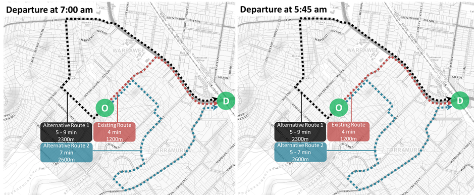
Right turn ban from Pacific Highway southbound into Finlay Road - Alternate traffic routes via Fox Valley Road (1) and Kissing Point Road (2)
- What would be the alternate route for Marshall Avenue motorists onto the Pacific Highway southbound?
Marshall Avenue is a cul-de-sac, which services Marshall Avenue residents only.
The crash history data for the intersection in the five-year period between 1 January 2011 and 31 December 2016 shows that there were 8 reported crashes at the intersection. The introduction of a right turn ban is expected to reduce crash rates at this intersection.
Based on the traffic counts collected in March 2017, the number of vehicles turning right out of Marshall Avenue onto the Pacific Highway southbound was found to be insignificant (three vehicles per hour in the AM peak and two vehicles per hour in the PM peak). In general, these vehicles can find a suitable gap to turn within half a minute in the 2017 AM peak and within 40 seconds in the 2017 PM peak. The delays in the AM peak would remain the same in 2027 while the delays in the PM peak would increase to 47 seconds in 2027.
The proposed right turn ban from Marshall Avenue onto the Pacific Highway southbound would see affected vehicles reroute via Fox Valley Road. The impacts, in terms of travel distance and time on a typical weekday during the AM and PM peaks, are shown below.
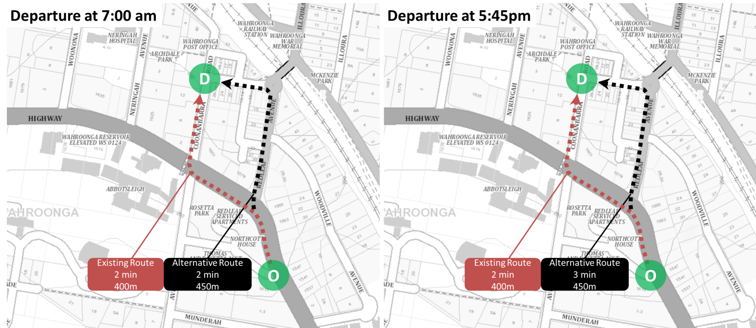
- What would be the alternate route for Pacific Highway motorists into Coonanbarra Road northbound?
Coonanbarra Road primarily services the surrounding residential and school community.
Currently the right turn movement from the Pacific Highway into Coonanbarra Road is an unprotected filter movement and considered unsafe.
Based on the traffic counts collected in March 2017, only a small number of vehicles were turning right into Coonanbarra Road from the Pacific Highway during both peaks (13 vehicles in the AM peak and 16 vehicles in the PM peak).
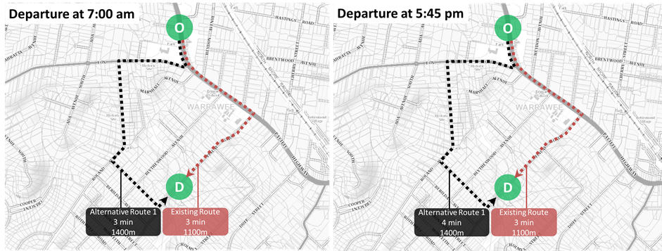
Banning the right turn movement from the Pacific Highway into Coonanbarra Road would see affected vehicles rerouted via Redleaf Avenue. As a result, this would increase the amount of right-turn movements into Redleaf Avenue by 23 vehicles in the AM peak hour and 15 vehicles in the PM peak hour. This would be a negligible increase given 163 vehicles currently turn into Redleaf Avenue in the AM peak and 155 vehicles in the PM peak.
The impacts, in terms of travel distance and time on a typical weekday during the AM and PM peaks, are shown below.
Right turn ban from the Pacific Highway northbound into Coonanbarra Road - Alternate traffic route via Redleaf Avenue.
- Why can’t traffic lights be installed instead of banning right hand turns?
The traffic flows on Finlay Road and Marshall Avenue do not meet the minimal warranted requirement for traffic light installation. Based on the traffic demand warrants a side, or minor, road would need to exceed 200 vehicles per hour in one direction for four hours to be considered for traffic light installation.
Based on the traffic counts collected in March 2017, the peak flow on Finlay Road is about 100 vehicles per hour in the westbound direction between 7.45am and 8.45am. Traffic flows are significantly lower at other times of the day.
Based on the traffic counts collected in March 2017, the peak eastbound flow on Marshall Avenue was about 30 vehicles per hour between 9.00am - 10.00am.
Therefore, there is insufficient traffic to consider traffic lights at Finlay Road or Marshall Avenue.
The addition of traffic lights in close proximity to each other increases total number of vehicle stops, and delays, on the traffic network which would remove the benefit of installing the additional lane.
Two sets of traffic lights close together is also a safety hazard where both sets of lights are visible to drivers.
- Why is a left turn from the Pacific Highway northbound into Fox Valley Road needed?
The dedicated left turn lane from the Pacific Highway northbound into Fox Valley Road is an existing traffic condition, which would be maintained under the proposed Pacific Highway and Fox Valley Road upgrade work.
Based on the traffic counts collected in March 2017, the number of vehicles turning left from the Pacific Highway into Fox Valley Road is high during both peaks (about 400 vehicles in the AM and PM peak hour). The existing traffic flow supports the maintenance of the dedicated left turn lane due to the high volume of left turning traffic from the Pacific Highway northbound.
The provision of the northbound left turn lane into Fox Valley Road allows turning vehicles to safely decelerate or stop without impacting the flow of the through traffic providing improved traffic flow on the Pacific Highway. The left turn lane also stores vehicles when the pedestrian crossing is in use.
- How would construction impact me?
There would be noise and traffic and transport related impacts during the construction of these works (refer to further FAQs below for more details).
The project is currently in design phase. Community consultation feedback will inform progression of the project, along with the proposed project's aims and design requirements, before we decide how we will proceed with the potential Pacific Highway upgrades.
Roads and Maritime acknowledges that any planned works may cause inconvenience for a small proportion of local residents, pedestrians and road users during the construction stage.
There would be, however, significant benefits which would be experienced by the thousands of motorists that travel through this section of the Pacific Highway corridor on a daily basis.
- What would be the noise impacts from the upgrade work during construction?
There would be noise impacts during the construction of these works, particularly during night time work.
A Review of Environmental Factors (REF) is being prepared to assess the environmental impacts of the proposal and to outline the measures that must be taken in order to manage and mitigate these impacts. The REF will include consideration of construction noise impacts to surrounding properties and identify suitable mitigation measures to minimise noise impacts from construction activities. These mitigation measures would be based on best practice and Roads and Maritime's Construction Noise and Vibration Guidelines.
As part of the construction planning, the contractor would be required to prepare a Construction Noise and Vibration Management Plan to ensure noise and construction impacts are minimised and managed effectively.
- What would be the traffic and transport related impacts from the upgrade work during construction?
There would be temporary traffic changes, including lane closures and change of speed limits, during construction to ensure the work zone is safe. This may affect travel times. We would work during night time wherever possible to minimise traffic impacts. As part of the construction planning, the contractor would be required to prepare a Traffic Management Plan to ensure traffic impacts are minimised and managed effectively.
Minor temporary pedestrian detours would be in place along sections of the footpath where road widening is proposed on the northbound side of the Pacific Highway. Where detours would be required on the footpath, signage and notifications would be provided to assist with these temporary changes.
Some bus stops on the northbound side of the Pacific Highway may need to be temporarily relocated or closed during construction. These changes would be communicated to the community via notification letters and signs posted at the bus stops. The project team would consult with the relevant transport providers, Ku-ring-gai Council and other stakeholders on any bus and transport changes.
We would keep the community updated on start of construction information including traffic and transport related changes that would result from start of work.
- How would the impacts on residents be managed during construction?
A Review of Environmental Factors (REF) is being prepared which assesses the potential environmental impacts of the proposal (both from construction and operation) and provides measures to manage and reduce these impacts based on best practice, expert advice and feedback from the consultation process.
Should the project proceed, a Construction Environmental Management Plan would be prepared before we start work to manage and mitigate the expected environmental impacts during construction based on the assessment and safeguards provided in the REF.
We would always notify local communities before starting a new section of work and before we do any out-of-hours work.
- Would people living adjacent to the Pacific Highway upgrade work experience more noise after works are completed?
Roads and Maritime undertake noise modelling for all of our projects, to predict noise levels after a project opens to traffic. Noise modelling has been carried out to understand what the future operational noise levels would be (relative to existing noise levels) following the Pacific Highway upgrades.
Noise modelling results have confirmed that there would be a slight increase in operational noise received by adjoining properties directly impacted by the proposal (no more than 2 dBA), however not to a level that would require consideration of noise mitigation treatment under Roads and Maritime's Noise Mitigation Guidelines. A-weighted decibels, abbreviated dBA, is an expression of the relative loudness of sounds in air as perceived by the human ear.
For more information on Roads and Maritime's noise management policies and procedures, please refer to Reducing noise.
- How can I find out more information on this project?
For more information on this Pinch Point project, please visit the project webpage or contact the Pinch Point project team on 1800 572 004 (during business hours) or pinchpoint@rms.nsw.gov.au.
If you would like to receive community updates by email please advise the project team by email or telephone.
- How do I contact the project team?
The Pinch Point project team can be contacted on 1800 572 004 (during business hours) or pinchpoint@rms.nsw.gov.au.
Project documents
Some documents on this page may not comply with accessibility requirements (WCAG).
If you are having trouble accessing information in these documents, please contact us.
Project updates
- October 2022 project update
Pacific Highway project between Turramurra and Wahroonga.
- June 2022 project update
Pacific Highway project between Turramurra and Wahroonga.
- April 2022 project update
Temporary footpath closure.
- December 2022 return to work flyer
Pacific Highway project between Turramurra and Wahroonga.
- December 2021 project update notification
Work continuing on the Pacific Highway between Turramurra and Wahroonga.
- October 2021 project update notification
Work continuing on the Pacific Highway between Turramurra and Wahroonga.
- June 2021 project update notification
Work continuing on the Pacific Highway upgrade at Fox Valley Road and Redleaf Avenue.
- March 2021 project update notification
Work continuing on the Pacific Highway between Turramurra and Wahroonga.
- January 2021 project update notification
Continuing work on the Pacific Highway upgrade from Monday 25 January.
- September 2020 community update
Pacific Highway upgrades between Turramurra and Wahroonga.
- September 2019 project update
September 2019 Project Update - Pacific Highway Redleaf and Connanbarra Notification Redleaf close of consultation.
- September 2018 project update
Pacific Highway upgrades between Turramurra and Wahroonga.
Project notifications
- December 2022 project notification
Turramurra and Wahroonga - now open to traffic.
- November 2022 project notification
Permanent change to traffic conditions.
- November 2022 project notification
Road pavement works.
- August 2022 project notification
Investigation work at 100-102 Fox Valley Road, Wahroonga from 22 August.
- August 2022 project notification
Impact to Myall Avenue residents.
- June 2022 project notification
Update – Footpath reopening.
- June 2022 project notification
Work continuing on the Pacific Highway between Turramurra and Wahroonga.
- March 2022 project notification
Work continuing on the Pacific Highway between Turramurra and Wahroong.
- November 2021 project notification
No right turn at the Redleaf Avenue onto Pacific Highway Northbound, Wahroonga from Sunday 5 December 2021.
- November 2021 project notification
Temporary closure of footpath on the Pacific Highway between Fox Valley Road and Myall Avenue from 21 November 2021.
- April 2021 start of work notification
Starting work to establish the site compound at Pearce’s Corner, Wahroonga from Monday 12 April.
- March 2021 project notification
Site compound on Fox Valley Road is moving.
- March 2021 project notification
Establishing a site compound at Pearce’s Corner, Wahroonga from Monday 12 April.
- October 2020 project notification
Permanent no right turns at the Pacific Highway/ Finlay Road intersection from Monday 2 November.
- October 2020 project notification
Site compound establishment at 100 – 102 Fox Valley Road, Wahroonga extended to Friday 6 November.
- September 2020 project notification
Site compound establishment at 100-102 Fox Valley Road, Wahroonga for the Pacific Highway upgrade.
- October 2020 project notification
Road work on the Pacific Highway between Turramurra and Wahroonga from Monday 12 October.
- September 2019 project notification
Pacific Highway notification investigation work testing.
- September 2019 project notification
Investigation work on Pacific Highway at Wahroonga.
- February 2018 project notification
Investigation work on Pacific Highway, between Turramurra and Wahroonga.
Reports
- August 2019 Review of Environmental Factors main report - Redleaf Avenue and Coonanbarra Road
Main report.
- August 2019 Review of Environmental Factors report - Redleaf Avenue and Coonanbarra Road
Appendices C-E.
- August 2019 Review of Environmental Factors report - Redleaf Avenue and Coonanbarra Road
Appendices F-I.
- August 2019 Review of Environmental Factors report - Redleaf Avenue and Coonanbarra Road
Appendices J-K.
- August 2019 supplementary community consultation report
Pacific Highway upgrades between Redleaf Avenue and Coonanbarra Road.
- April 2019 community consultation report
Pacific Highway upgrades between Turramurra and Wahroonga.
- April 2019 review of environmental factors report
Pacific Highway Intersection Upgrade - Finlay Road and Fox Valley Road.
- April 2019 review of environmental factors report - Pacific Highway Intersection Upgrade - Finlay Road and Fox Valley Road
Appendices A - G.
- April 2019 review of environmental factors report - Pacific Highway Intersection Upgrade - Finlay Road and Fox Valley Road
Appendices H -I.
- April 2018 review of environmental factors report
Appendice J.
Contact us
For further information about this project, please contact:
Phone: 1800 897 841 (during business hours)
Email: projects@wardcivil.com.au
Mail: Transport for NSW, PO Box 973, Parramatta NSW 2124.