Kingsford to Centennial Park walking & cycling
Project overview
The Australian and NSW Governments are delivering walking and cycling improvements to provide an active transport link between Kingsford and Centennial Park.
Latest news
August 2025 – start of work
From Sunday 24 August Transport for NSW is starting work to convert an existing section of the Kingsford to Centennial Park cycleway from a shared path to an on-road, separated cycleway.
The existing shared path design was implemented as an interim measure as we worked towards a final arrangement at the intersection. Extending the separated cycleway through the intersection provides the safest solution for all road users in particular people walking and people of all ages riding bikes.
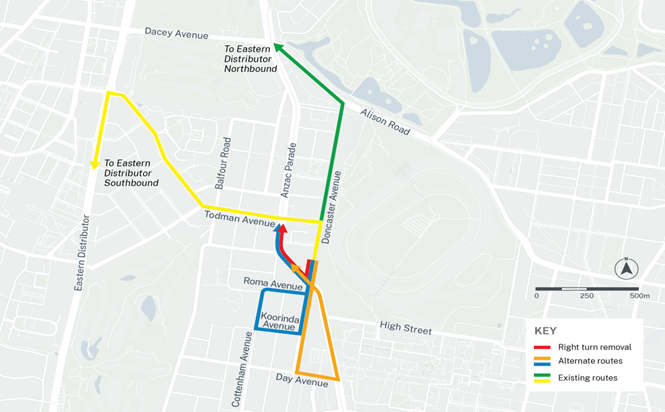
As part of this upgrade, the existing right-turn movement from Doncaster Avenue (southbound) onto Anzac Parade will be removed.
We appreciate your ongoing support as we work to deliver a safer and more connected active transport network for everyone.
View the August 2025 start of work notification (PDF, 370.68 KB) and see the content on this page.
Project information
Background
The project, developed by Randwick City Council and being delivered by Transport for NSW, was part of a $240 million investment by the Australian and NSW Governments to fix congestion hotspots, expand the cycling network and help the economic recovery.
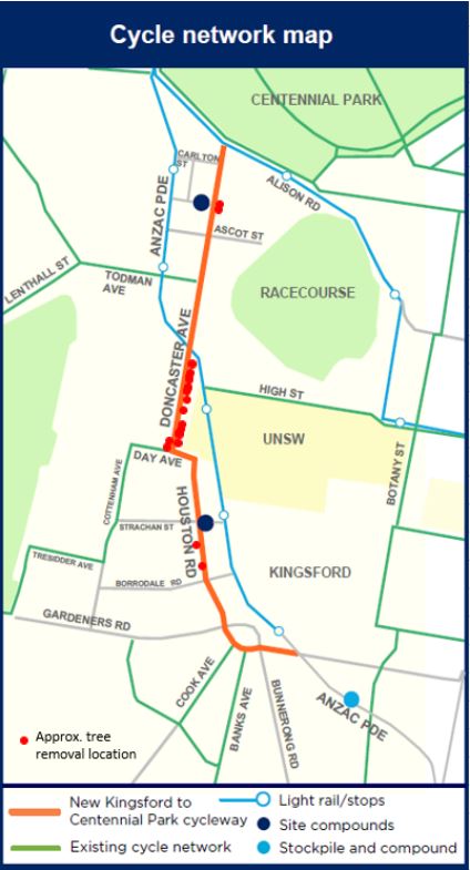
It includes a 2.8km two-way cycleway and shared path improvements along Doncaster Avenue, Day Avenue, Houston Road, General Bridges Crescent and Sturt Street. This will provide the local community and commuters with a safe and convenient active transport option and improve accessibility.
The cycleway will connect the Kingsford Light Rail terminus to the Centennial Park cycleway at Alison Road, Randwick. It will also connect to Randwick City Council’s planned cycleway between South Coogee and Kingsford.
Improvements also include new landscaping and trees, street lighting, traffic calming, seating, bike parking and stormwater drainage.
The project area is broken into 3 sections; sections 1 and 2 were completed and opened in December, 2023.
We are working with Council on a revised scope for Section 3 .
The current separated cycleway finishes at Barker Street where there is a new raised pedestrian crossing (shown in blue on map). Bike riders will transition back to the existing on-road marked cycleway.
Benefits
We are committed to encouraging people to walk or cycle as part of their everyday travel. Walking and cycling for commuting and short trips relieve pressure on our roads and public transport networks, and are part of a healthy lifestyle for our communities.
With the completion of Sections 1 and 2, the project has delivered:
- improved pedestrian and road safety user safety with new crossings, upgraded paths and traffic calming measures
- improved bike rider safety with a new two-way 2.8km separated cycleway
- improved accessibility for wheelchairs and prams
- improved streetscape with new trees, plants and landscaping
- provided more places to sit and enjoy the surrounds
- provided more bike parking
- improved street lighting for safety and security
- improved stormwater drainage to address flooding of properties and roads.
Earlier Consultation
In 2018, Randwick City Council consulted with the local community on the concept plan. More than 400 submissions were received with approximately 70 per cent supportive of the project.
The plan was refined to address community feedback where possible and the Review of Environmental Factors (REF) received planning approval in May 2019. An Addendum REF assessing the compound locations and clarifying the scope of tree removal was approved in September 2021.
Visit the Randwick City Council website for more information.
Design and Project Details
In collaboration with Randwick City Council, we incorporated required design changes for stormwater infrastructure along the project alignment, within the scope of this project.
This new drainage will help protect properties, as well as the road network, from stormwater and flooding.
The new stormwater infrastructure is along Doncaster Avenue and Day Avenue.
You can view the revised July 2022 design plans (PDF, 5.15Mb) and the initial 2021 design plans (PDF, 5.68Mb).
Trees
Due to the impact of the new stormwater drainage infrastructure and construction methodology, additional tree removal was required.
Environment specialists and arborists from Randwick City Council and Transport for NSW have carefully assessed each tree. We have worked together to minimise the impacts on each tree.
However, this essential stormwater work required the removal of about 20 additional trees. These will be replaced by 60 new native trees and planted by Randwick City Council.
Previously, approval was granted to remove 27 trees to improve safety, allow for new kerb and footpaths and to relocate utilities. Some trees are also being replaced as they are nearing the end of their expected life.
In total, we will be removing approximately 47 trees along the route and replacing them with over 141 native trees.
The trees being removed have been assessed as part of the Review of Environmental Factors. They are mainly non-native trees and were found not to be ecologically sensitive. Every effort has been, and will continue to be, made to minimise the loss of trees associated with the project.
Tree Replacement Consultation
Randwick City Council consulted on the replacement tree species and potential locations in August 2022. Council have selected tree species that align with their tree planting plans and meet Ausgrid requirements.
Find out more at Walking and cycling improvements: Kingsford to Centennial Park | Your Say Randwick (nsw.gov.au)
Permanent parking changes
About 20 parking spaces will be permanently removed as part of the project. This includes 34 parking spaces removed and 14 spaces added across the project alignment.
These parking changes will make room for new, safer pedestrian crossing areas and to maintain safe vehicle access to properties and businesses.
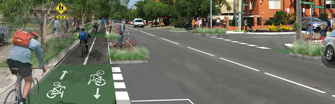
Extended separated cycleway at Anzac Parade and Doncaster Avenue intersection
Construction
Transport for NSW is converting an existing section of the Kingsford to Centennial Park cycleway from a shared path to an on-road, separated cycleway.
From Sunday 24 August we are starting construction to extend the separated cycleway on Doncaster Avenue through the intersection at Anzac Parade.
As part of this upgrade, the existing right-turn movement from Doncaster Avenue (southbound) onto Anzac Parade will be removed.
Work hours
We will be working on Doncaster Avenue at the intersection of Anzac Parade for up to 22 nights between Sunday 24 August and Thursday 9 October, weather and site conditions permitting.
Our work hours will be between 7am to 5pm, Monday to Friday and 7pm to 5am, Sunday to Thursday.
Some of our work needs to be carried out at night to minimise traffic disruption and reduce safety risks to workers and motorists. We will not work on Friday night, Saturdays, or public holidays.
If you have any complaints or questions about this work, contact our contractor Ward Civil on 1800 897 841 and projects@wardcivil.com.au.
Location of work area

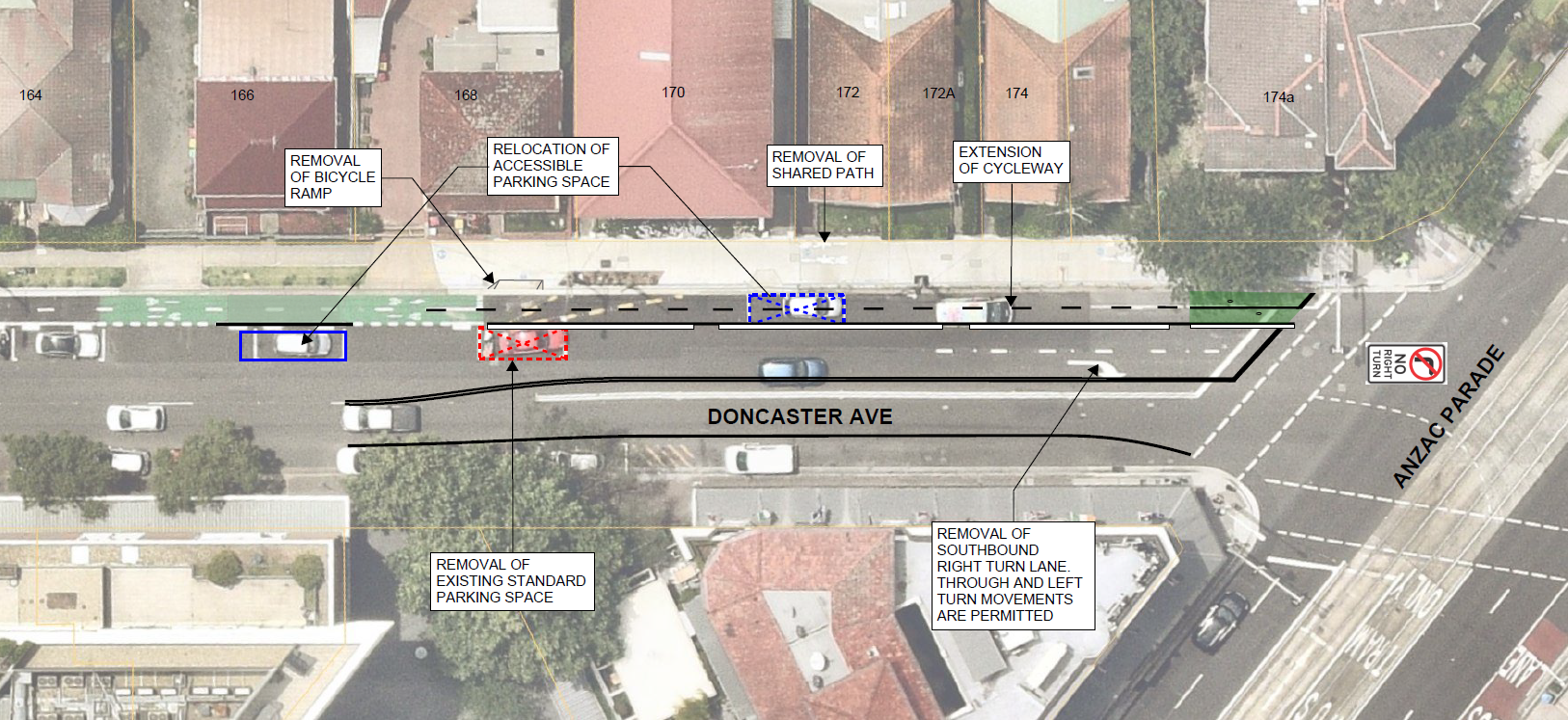
What’s changing?
- extending on-road cycleway through the intersection
- relocating a disabled parking space and removing two parking spaces on the northern side of Doncaster Avenue
- removing the southbound right-turn from Doncaster Avenue into Anzac Parade
- removing the shared path
- adjusting kerbs and installing new footpath ramps
- changing traffic light sequencing
Managing our impacts
We will do everything we can to minimise our impacts including:
- completing noisiest tasks (saw cutting and jack hammering) by midnight.
- using quieter equipment where possible
- installing noise curtains
- reducing our noise as much as possible
We will liaise directly with nearby properties and businesses to minimise impacts.
Background
The existing shared path design was implemented as an interim measure as we worked towards a final configuration at the intersection.
Extending the separated cycleway through the intersection provides the safest arrangement for all road users in particular people walking and people of all ages riding bikes.
This final design provides a continuous separated cycleway and removes conflict on the existing shared path as shown in the images on this page.
Benefits:
- provides the safest arrangement for all road and footpath users and minimises conflicts between people walking and riding bikes
- improves efficiency for people walking, riding bikes and driving
- allows people riding bikes to safely continue on the cycleway through the intersection
- provides clear guidance for people riding bikes when they reach this intersection
- allows the through lanes to be widened to better accommodate vehicle turning movements at Anzac Parade
- maintains parking and loading zones on the western side of Doncaster Avenue
Impacts to parking
There will be some changes to several parking spaces on the eastern side of Doncaster Avenue. We are liaising directly with any impacted properties.
We propose to remove one parking space and relocate an accessible parking space as shown on the map.
Northern Side of Anzac Parade
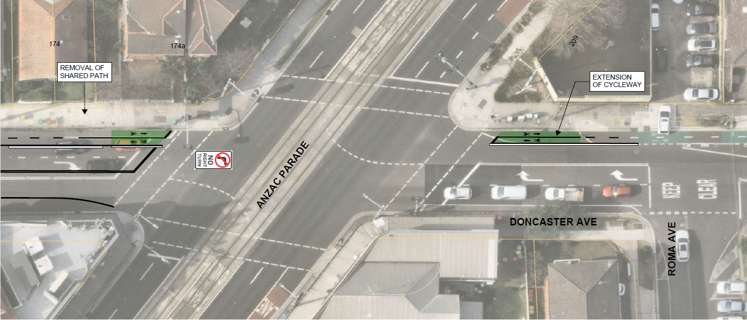
Southern side of Anzac Parade
Alternate routes
Traffic analysis supports this change, as right turns are less frequent and there are alternate routes as shown on the map.
Alternate routes map
Options considered
We assessed several options for improving the safety at this intersection including:
- providing an on-road separated cycleway, including the removal of southbound right turn lane (proposed option)
- retaining the existing interim shared path arrangement
- providing a split cycleway design with one direction on the shared path and the other on the road
- providing an on-road separated cycleway by removing parking and loading zones on the western side.
The on road separated cycleway, including the removal of southbound right turn lane, has been recommended as the safest option as it:
- provides the safest arrangement for all road and footpath users and minimises conflicts between people walking and riding bikes
- is the safest option for people walking and riding bikes
- provides clear guidance for people riding bikes
- allows the through lanes to be widened to better accommodate vehicle turning movements at Anzac Parade.
Consultation outcomes
The community were invited to provide feedback on the proposed design from Thursday 19 September to Friday 18 October 2024.
We distributed a community notification, sent emails, installed local posters, door knocked nearby properties and contacted everyone who requested a follow up. We provided an online feedback form for all community feedback as well as emails and phone calls.
We received 88 comments on the proposed change, most of which were supportive of extending the on-road cycleway and removal of the right-turn on Doncaster Avenue to improve safety for all road and footpath users.
Other comments related to specific suggestions for the cycleway design, access into and out of driveways, parking challenges and other non-project related feedback. Feedback relating to the cycleway in general has been provided to Council.
Sections 1 and 2 - Alison Road to Barker Street
Update
Sections 1 and 2 have been completed. This delivers 1.8km of separated cycleway to improve bike rider safety.
To improve pedestrian and road user safety we:
- upgraded traffic signals at Todman / Doncaster Avenue intersection
- installed new raised pedestrian crossings at the Darling / Doncaster and Day / Doncaster intersections and two new pedestrian crossings at the Barker/ Houston intersection
- installed or upgraded 23 pram ramps
- replaced 2500m2 of concrete footpath and upgraded 48 driveways.
To improve safety and security at night we:
- re-aligned and upgraded 22 streetlights
- installed eight new floodlights at the new pedestrian crossings.
To improve stormwater drainage and address flooding we:
- installed over 780m of stormwater pipes, 75 stormwater pits
- replaced over 1000m of kerbs and gutters.
We have reused 65m of existing sandstone kerb into the new cycleway.
We also completed the landscaping and installed benches and bike racks.
Image


Image controls:
Section 3 - Barker Street to Sturt Street
Update
We experienced extensive delays and budget impacts due to weather, escalating costs, shortage of workers and design challenges such as stormwater work and tree impacts. This impacted on our program and changed how the project was delivered.
The remaining Section 3 (between Barker St and Sturt St) will be delivered at a later stage. Transport and Council will continue to work together to review the design options to deliver this important cycleway, which will provide a safe route for bike riders and enable new connections around the area.
Transition at Section 3
The new separated cycleway finishes at Barker Street where there is a new raised pedestrian crossing.
Bike riders transition back to the existing on road marked cycleway. Signs and line marking are in place to guide cyclists through this transition.
Project documents
Some documents on this page may not comply with accessibility requirements (WCAG).
If you are having trouble accessing information in these documents, please contact us.
Community notifications
- August 2025 start of work notification (PDF, 370.68 KB) - Start of work – Doncaster Avenue and Anzac Parade, Kensington
- March 2025 community notification (PDF, 613.42 KB) - Consultation outcomes and next steps for the on road cycleway extension and intersection changes
- Community consultation report February 2025 (PDF, 2.35 MB)
- September 2024 community notification (PDF, 548.38 KB) - On road cycleway extension at Doncaster Avenue and Anzac Parade intersection
- November 2023 community notification (PDF, 1.19 MB)- Project completion, Section 2 opening and update on Section 1
- September 2023 community project update - Update on Section 3
- October 2023 community notification (PDF, 291.2 KB) - Out of hours work and project lookahead
- Out of hours and project lookahead (PDF, 312.85 KB) - August to September 2023
- July 2023 community notification (PDF, 286.37 KB) - Out of hours work and project lookahead
- July 2023 community notification (PDF, 316.71 KB) - Upcoming work, and temporary road closure and detour Doncaster Avenue and Darling Street, Kensington
- Out of hours and project lookahead (PDF, 289.33 KB) - June 2023
- June 2023 community notification (PDF, 278.77 KB) - Road resheeting and concrete works on Day and Doncaster Avenue
- Out of hours and project lookahead (PDF, 268.86 KB) - May 2023
- May 2023 community notification (PDF, 371.27 KB) - Temporary work, traffic changes and detour - Houston Road near Barker Street
- Out of hours and project lookahead (PDF, 947.94 KB) - March to April 2023
- January 2023 community notification - Temporary work, traffic changes and detour - intersection of Barker Street and Houston Road
- January 2023 community notification - Temporary work, traffic changes and detour – intersection of Day Avenue and Doncaster Ave
- December 2022 community project update - Upcoming work and permanent and temporary parking changes
- November 2022 community notification - Night work, road closure and detour – intersection Day Ave and Doncaster Ave
- Out of hours and project lookahead - November to December 2022
- Out of hours and project lookahead - September to October 2022
- August 2022 community notification - Upcoming work and parking changes – Doncaster Avenue between Anzac Parade and Koorinda Avenue
- August 2022 community project update
- Out of hours and project lookahead - July to August 2022
- Out of hours and project lookahead - May to June 2022
- Out of hours and project lookahead - March 2022
- February 2022 start of work
- October 2021 community project update - Kingsford to Centennial Park walking and cycling improvements
- November 2020 early work - Community notification
Contact us
For further information about this project, please contact:
Phone: 1800 650 031